Taken in isolation, this accident is simply the case of a captain's poor decision making and instrument flying skills. But there is much more to it than that. But there is yet another aspect to this accident that is even more important. The captain behaved without regard to instrument procedure and the first officer was a passenger in the right seat. It was a part of the airline's culture.
— James Albright

Updated:
2018-02-01
Pan Am Boeing 707-121, N708PA, 1959, (Paddy Ballard)
This was another incident in a series of 13, 11 of which pointed to a problem with the Crew Resource Management culture at Pan American World Airways at the time. They were able to reverse this culture and became one of the safest airlines in the world.

1
Accident report
- Date: 17 September 1965
- Time: 07:24
- Type: Boeing 707-121B
- Operator: Pan American World Airways
- Registration: N708PA
- Fatalities: 9 of 9 crew, 21 of 21 passengers
- Aircraft fate: Destroyed
- Phase: En route
- Airport (departure): Fort de France-Lamentin Airport (TFFF), Martinique
- Airport (arrival): Antigua-Coolidge International Airport (TAPA), Antigua and Barbuda
2
Narrative
The flight data recorder did not survive the crash and most of the evidence comes from recollections of radio conversations and eye witnesses. Nevertheless, it is possible to deduce the aircraft was flight planned to fly a straight line from Martinique and Antigua. A weather system would appear to have made a westerly deviation prudent. Air traffic control instructions were to cross Guadeloupe, just south of Antigua, at 8,500 feet and to overfly Antigua at 2,500 feet. The crew was seen descending to 1,000 feet well short of Antigua.
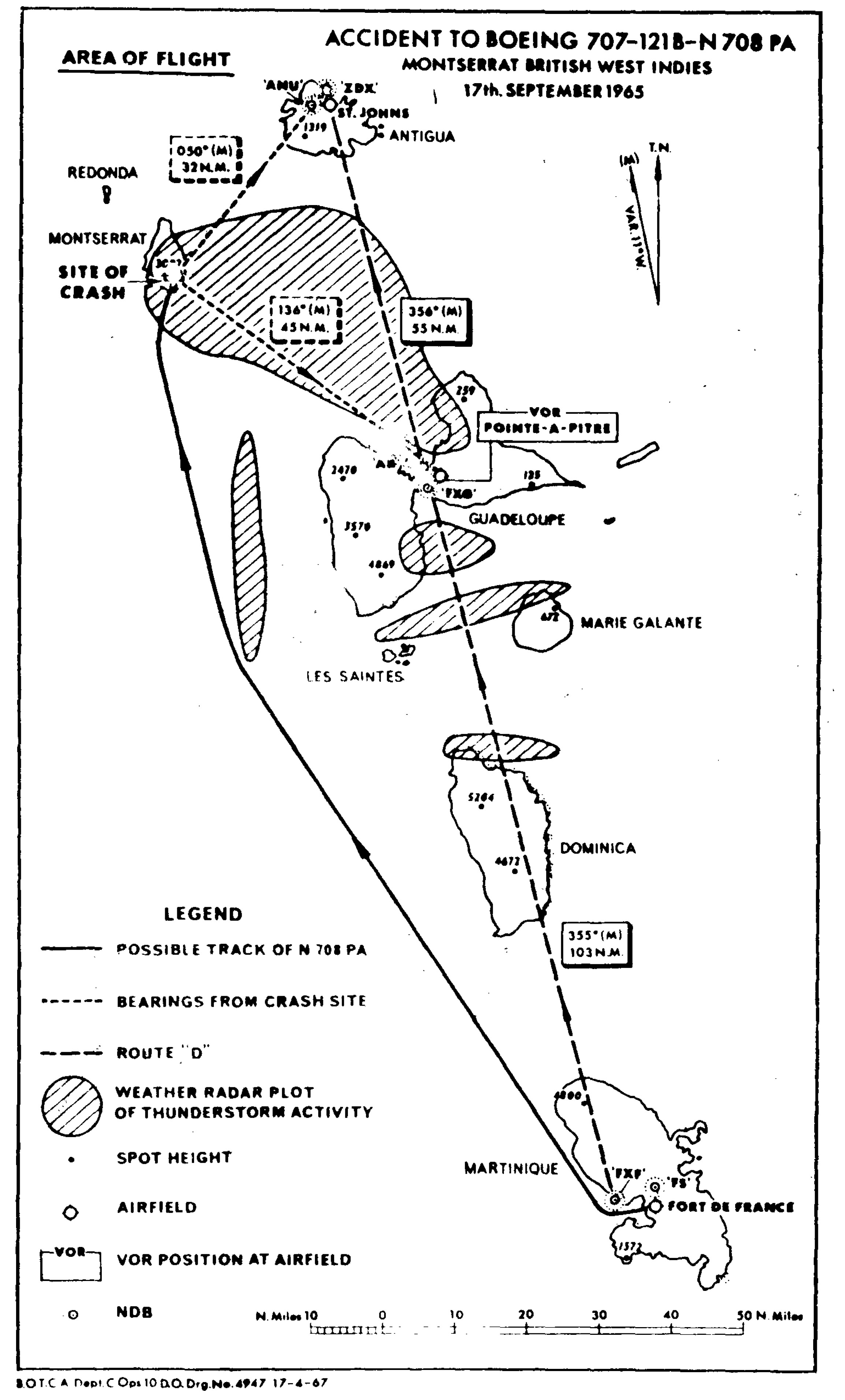
Pan Am 292 area of flight, ICAO Circular 88-AN/74, Appendix 1.
- With Captain Henderson in the left-hand pilot's seat, the aircraft departed from the terminal at 1100 hours and it took off on runway 27 at 1104 hours. ATC clearance had been received for route D at flight level 165, to cross the terminal control area boundary at flight level 80 or above. According to the handwritten log kept in the tower at Fort-de-France, the aircraft reported at flight level 80 and climbing to flight level 165 at 1108 hours, after which it was told to contact Piarco. The transcript of the recordings at Piarco control centre, Trinidad, show that at 1106 hours the aircraft established contact with Piarco, and at 1109 hours it reported at flight level 165. There was no report of the aircraft being overhead the VOR at Pointe-a-Pitre (Guadeloupe) and descent clearance was recorded at Piarco as being given at 1112 hours and acknowledged at 1113 hours. The clearance was as follows:
"Clipper two nine two is cleared descend to cross Coolidge* beacon at two thousand five hundred feet altimeter one zero one six contact Coolidge approach at one five no delay expected cross Guadeloupe beacon not below flight level eight five over."
* The airport at St. Johns, Antigua, is also known as 'Coolidge' Field.
Source: [ICAO Circular 88-AN/74, No. 2, ¶1.1
The aircraft was set up to fly an instrument approach which would have required them to overfly the airport at 2,500' but because of the terrain between them and the field, to stay above 8,500' until passing Guadeloupe, the island just south of their destination island.
- According to the recollection of the controller at St. Johns, the aircraft called him at about 1115 hours and was cleared to Coolidge ZDX beacon (NDB) at 2,500 ft, and told to report at the beacon outbound leaving 2,500 ft or field in sight. During this exchange of messages, the aircraft indicated it was at flight level 115 descending. St. Johns tower then passed the landing conditions including the following information:
- The aircraft was also advised that the runway in use was 07 and that there was a considerable build-up (of cloud) to the south through south-west moving westerly. This information was acknowledged by the aircraft. At approximately 1125 hours the aircraft reported through flight level 40 and gave an amended ETA of 1130 hours. The controller in the tower stated that he then asked the aircraft whether the field was in sight, and on receiving the reply "negative" he told the aircraft to continue the approach and to report when visual contact was established.
- The recollections of two of the occupants of a Twin Bonanza aircraft which took off from St. Johns for St. Kitts at 1118 hours have provided accounts of what was said on the RT that are different in detail. [ . . .] The passenger who was sitting in the right-hand front seat of the Twin Bonanza also heard the controller when he instructed Clipper 292 to report passing through 2,500 ft or field in sight. He stated that shortly after this he heard Clipper 292 tell the tower: "I have your coast in sight". There was no further RT contact with the aircraft.
Wind: about 090°, 12 kt.
Cloud base: estimated at 1,700 ft.
Temperature: 27° in the tower
QNH: 1016.1 mb
Source: [ICAO Circular 88-AN/74, No. 2, ¶1.1
In their route of flight, there were multiple coasts that could have been in sight: Dominica, Marie Galante, Guadeloupe, Montserrat, and Antigua.
- A number of eyewitnesses at different points along the south-west coast of the island of Montserrat saw the aircraft approach and cross the coast in the vicinity of the radio station at O'Garra's estate. It was flying in rain below cloud with the landing gear extended and partial flap visible. One witness identified the PANAM insignia on the fin and rudder, and estimated that the aircraft was in his view for nearly one minute. Between this witness and the aircraft was one of two radio masts 263 ft high and the aircraft was seen to be aligned with a point 18 ft from the top of the mast, Taking into consideration the best available evidence of the horizontal distance between the witness and the track of the aircraft, the height has been deduced by simple trigonometry as being 1,089 ft above sea level when it crossed the line of sight of the witness near the coast. The observations of a second witness who saw the aircraft aligned with the top of one mast, indicated that the aircraft was 1,178 ft above sea level when calculated on the same basis. After crossing the coast, the aircraft continued to fly in a north-easterly direction and sight of it was lost as it entered cloud covering the high ground on the centre of the island, Shortly afterwards the engine noise, which had been continuous and loud, ended abruptly with the sound of an explosion.
- The weather conditions at Montserrat at the time of the crash included heavy and thunder with cloud covering the high ground, but small patches of blue sky were visible towards the south-west. The time of the accident was probably between 1123 and 1128 hours and the location has been determined as 16° 42' 18" N and 62° 10' 58" W.
- The wreckage was located on the steep jungle-covered southern slopes of Chance Mountain with the point of impact 242 ft below the summit which was 3 002 ft above mean sea level.
Source: [ICAO Circular 88-AN/74, No. 2, ¶1.1
Both pilots' altimeters were severely damaged and no readings were possible from the faces of the instruments, but in both cases it was possible to observe the positions of the 1,000 ft increment altitude drums by means of cutting inspection 'windows'. By comparing these positions with the equivalent on a serviceable instrument, it was deduced that each instrument was reading between 2,000 ft and 3,000 ft altitude at the time of impact.
Source: [ICAO Circular 88-AN/74, No. 2, ¶1.1
3
Analysis
If your aim is to establish guilt or innocence, there is enough doubt here to say perhaps the flight instruments misled the pilots into thinking they were farther north than they actually were. But that isn't our aim here; we are here to extract flying lessons. Given that, it looks like the pilots deviated off course for weather and then began their descent based on a momentary view of an island coastline.
- There is no evidence from the records of the communications, observed or apparent manoeuvres of the aircraft or examination of the wreckage that the aircraft and its engines were other than mechanically sound and capable of responding to the control actions of the crew at the time of the accident. Its collision with high ground is consistent with the aircraft descending under the control of the pilots when they believed its position was such that an altitude of 2,760 ft provided a safe margin above the terrain.
Source: [ICAO Circular 88-AN/74, No. 2, ¶2.1
They were unable to recover many of the flight instruments, some of which had histories of malfunctioning. But the preponderance of evidence ruled out mechanical malfunction.
- The circumstances of the aircraft's departure from Fort-de-France were unremarkable but consideration of all the relevant meteorological data indicates that there was a substantial area of cumulonimbus cloud and thunderstorm activity on the route during the period of the flight, particularly to the north and west of Guadeloupe and extending as far as 30 NM to the west of the direct track to St. Johns. This activity would have been visible to the pilots and apparent on the aircraft weather radar. While the destruction of the flight recording precludes certain knowledge of the route followed, the position of the crash can indicate that the captain elected to deviate to the west of the direct track to avoid the worst of the weather and it is accepted that in the prevailing conditions this was a prudent course to take. The undefined extent of the deviation invalidates any detailed analysis of the flight on a time/distance basis, but the RT records provide sufficient data relating to a time/altitude analysis to conclude that the flight profile was normal for a short sector (158 NM by the direct route), that is, a climb to flight level 165 followed by a cruise for 3 or 4 minutes at altitude and then a descent.
Source: [ICAO Circular 88-AN/74, No. 2, ¶2.1
While FL165 for a 158 NM trip isn't too unusual these days, it would have been a poor altitude for a Boeing 707, requiring a rushed descent at some point.
- The handwritten log at Fort-de-France records take-off time as 1104 hours and the attainment of flight level 80 at 1108 hours, after which the aircraft was told to contact Piarco, but the recordings at Piarco registered 1106 hours as the time contact was established with that station. It is possible, with the duplicated VHF communication equipment for one pilot to be in contact with Fort-de-France while the other is speaking to Piarco, but in the circumstances there is little purpose in doing so. It is more likely that the time recording at one or both ground stations was incorrect, especially when considering that the flight manual performance charts give a time of 12 minutes for climb to flight level 165, while comparison of the take-off time logged at Fort-de-France (1104 hours) with the recorded time the aircraft reported at flight level 165 according to the Piarco log (1109 hours) gives 5 minutes for the climb differences in time to climb to a given altitude are possible with different climb techniques but the large margin of difference apparent in this case is unrealistic.
Source: [ICAO Circular 88-AN/74, No. 2, ¶2.1
Both pilots were highly experienced but both had fewer than 300 hours in the Boeing 707, which was their first jet. It would have been easy for them to miss the fact that FL165 was an unreasonable altitude. Looking at the time line it seems they never made it to their filed altitude and at some point had to go from "climb mode" to "descent mode" unexpectedly, and that would have put them into a rush to get things done in time for the landing.
- Once the deviation from a direct line joining the en-route radio navigation aids had taken place, it was only possible to keep track of the aircraft's position by pilot navigation methods involving dead reckoning calculation, ADF and VOR bearings and such supplementary information as was admissible from the weather radar. Frequent changes of direction, dictated by the need to avoid the worst of the weather, coupled with the aircraft's high speed would reduce the accuracy of the dead reckoning. Static interference originating in the thunderstorms would have reduced the dependability of the ADF indications but the VOR should have remained mostly unaffected. The pilots' relative inexperience of jet aircraft operations may have added to their difficulties in retaining a mental appreciation of the position of the aircraft. The captain had flown a total of 297 hours in Boeing 707 aircraft and the co-pilot and second officer less than this; whilst there is no reason to doubt their competence in handling the aircraft, their substantial experience in navigating piston-engined aircraft in the Caribbean area needed to be modified to take account of the higher speeds and altitudes which compress distance and flight time. In the earlier stages of experience this requires conscious effort, while more experienced pilots are likely to contend with these factors as a matter of course.
Source: [ICAO Circular 88-AN/74, No. 2, ¶2.1
The captain had flown the route many times and was issued topographical charts of the area. But these charts were found inside his brief case.
- Consideration of the navigational aspects of the flight may be summarized as follows:
- The aircraft deviated from the direct route between Fort-de-France and St. Johns but the absence of reliable data precludes an accurate reconstruction of the flight path.
- The possibility that there might have been a faulty presentation of heading information on the co-pilot's instrumentation cannot be ruled out in the light of the history of instrument defects, but examination of the wreckage indicates that such a fault was not present at the time of impact. The accuracy of the captain's compass system remains unknown but there is no history of related defects as in the case of the co-pilot's instrument.
- Evidence regarding the positions of the RMI pointers is inconclusive and it is considered unrealistic to draw conclusions from the examination of the RMI pointer components.
- Of the two ADF receivers on board, only one was recovered and this was probably tuned to the lower powered of the two NDBs at St. Johns. It is likely that the single VOR receiver recovered was selected to the frequency of Guadeloupe VOR. Both of these settings are consistent with normal navigational practice on this route.
- There were no abnormal radio propagation effects which may have degraded or distorted the VOR signals significantly at the relevant time.
- There is, therefore, no direct evidence of any faulty presentation of navigational information by those instruments which were recovered but since the examination of some instruments produced inconclusive results and evidence was not available from the unrecovered components, the possibility that the pilots may have been misled by some of them cannot be ruled out with absolute certainty. In this connection, it is possible to develop an hypothesis involving a repetition of the circumstances of the flight on the same route in the subject aircraft on 10 September 1965, when the co-pilot's RMI seized on a heading of 002°M during the descent to Antigua and corrected itself on the final approach to land. If the flight in which the accident occurred had been made by the direct route, the selected course of between 000° and 009° found on the captain's PDI could be accounted for as the course necessary to overfly Pointe-a-Pitre VOR in order to correct for having made a westerly take-off on runway 27 at Fort-de-France. Allowing for an easterly wind of 15 kt at cruising altitude and a track of 356°M after passing the VOR, a compass heading of 002° would seem reasonable to the pilots especially if the No. 2 pointers, which could have been selected to ADF and their receivers tuned to an NOB at Antigua, were pointing generally ahead. The magnetic bearing of the destination would in this event indicate an approximate 'on track' situation, while it is possible that with the co-pilot's RMI seized on 002°M the aircraft was heading well to the west of track. At the same time, the magnetic bearing of the Pointe-a-Pitre VOR would have been misrepresented on the co-pilot's RMI by the amount the real heading of the aircraft differed from the seized heading of 002°M plus any possible error in the No. 1 pointers if they were selected to VOR. It is possible to elaborate on this hypothesis at some length and, in given conditions, pose a situation where the readings of the co-pilot's RMI indicated an aircraft position about 9 miles south-south-west of Antigua when it was in fact in a similar position in relation to Montserrat. However, it does not provide a reason why the captain ignored his own RMI readings and the evidence in its support is tenuous and to some extent circumstantial.
Source: [ICAO Circular 88-AN/74, No. 2, ¶2.1
4
Cause
The pilots appeared to forget they were flying under instrument flight rules because they could see the ocean and various islands below them. They neglected minimum safe altitudes without being sure of their position and crashed into a mountain on an island southwest of their intended island. How could two pilots of the world's leading airline, at the time, fly so poorly? Because that airline, at the time, had a culture of poor flight discipline and one where the captain's decisions could not be questioned.
- The aircraft was flown to the west of the direct route from Fort-de-France to St. Johns, either to avoid thunderstorms or as a result of an erroneous heading indication. An error was made in the navigation of the aircraft which was coupled with the misidentification of the coastline of Montserrat for that of Antigua.
- The accident was the result of the aircraft descending below a safe height when its position had not been accurately established.
Source: ICAO Circular 88-AN/74, No. 2, ¶2.1
References
(Source material)
Gandt, Robert, Skygods: The Fall of Pan Am, 2012, Wm. Morrow Company, Inc., New York
ICAO Circular 1969, 88-AN/74, Aircraft Accident Digest No. 17 Volume II, ICAO, Montreal, Canada