It is an elegant idea but that isn't the point. Your FMS uses these oceanic codes to represent various points around the globe so you need to know how to decode the code. Your approach plates use the VOR/DME codes to identify some of the waypoints. Once you've understand how the points are built, you will be able to crosscheck what is on your screen with reality.
— James Albright

Updated:
2015-09-23
Note there has been a change to the specification in the North Atlantic to allow for half-degree latitude spacing. This was first implemented in 2014 by moving the "N" a few spaces but so many pilots were misplacing the "N" that they suspended the change for a year. It looks like it is back, using an "H" but as of June 2015 the change is just finding its way into FMS coding. You should always double check the coding translates into the correct latitude and longitude. If you are assigned a waypoint using half-degree latitudes, especially so.
The specification itself comes these days from Rockwell-Collins, costs $504.00, and covers a lot more than what you as a pilot needs. You can, however, piece together the important stuff from other sources, which I've done below.

1
Oceanic waypoints
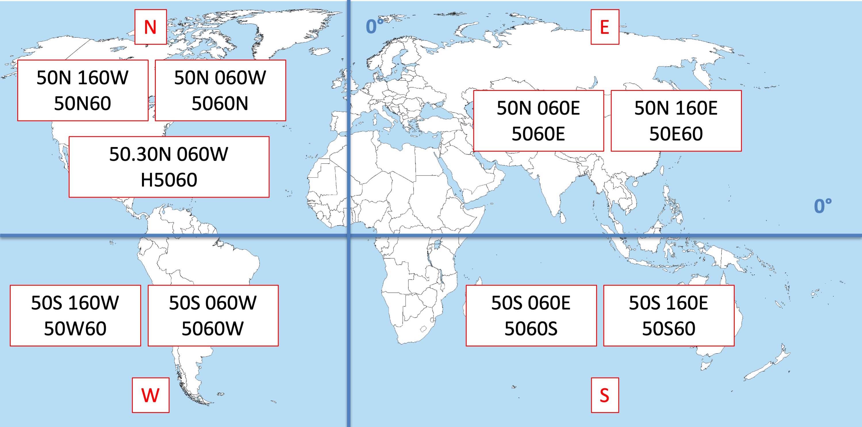
ARINC-424 shorthand lat/long hemispheres
The following comes from a Gulfstream manual but it describes the ARINC 424 specification for naming oceanic waypoints. If your aircraft uses this specification, these codes should work for you. Note: most FMS do not employ a code for every single latitude/longitude combination to save database space, just the more popular ones. The manual didn't consider half degree waypoints. More on that later.
[G450 Aircraft Operating Manual, §2B-31-20, Table 1]
- These waypoints are named according to ARINC 424 navigation database specification
- Southern hemisphere uses the letters S or W
- Northern hemisphere uses the letters N or E
- Latitude always proceeds longitude
- Only the last two digits of longitude are used
- Placement of the letter designator (N, S, E, W) in the string of five characters indicates the value of the longitude one-hundredths digit
- The letter in the last position indicates longitude is less than 100
- The letter in the third position indicates longitude is 100 or greater
| Letter | Lat | Lon |
| N | North | West |
| E | North | East |
| S | South | East |
| W | South | West |
- Examples:
- N 52 00/W 075 00 = 5275N
- N 75 00/W 170 00 = 75N70
- S 50 00/E 020 00 = 5020S
- N 50 00/E 020 00 = 5020E
- S 52 00/W 075 00 = 5275W
Half-degree waypoints are used in parts of the North Atlantic and the ARINC-424 code has been changed a few times as a result. The latest version is based on an ICAO NAT OPS Bulletin and reported in the following Jeppesen letter.
- Jeppesen will add Half Degree Grid Waypoints in the Gander and Shanwick Oceanic Control Areas (OCAs) according to section 2 of the ICAO NAT OPS Bulletin beginning in NavData cycle 1510, effective 17 September 2015. Half Degree Grid Waypoints for all other North Atlantic Regions will be added on or after NavData cycle 1512.
- Jeppesen will use the Identifier Naming Convention provided in section 5.3 of the bulletin, which states: “Hxxyy, where xx = degrees and 30 minutes of NORTH latitude and yy = degrees of WEST longitude (e.g., H5250 = 52°30’ NORTH 050°00’ WEST).”
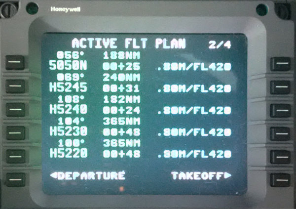
Half-degree waypoint examples
As you can see from the photo, the half-degree inputs do indeed work. In the photo below you see the results.
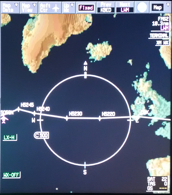
G450 map display, half-degree example
2
Oceanic example
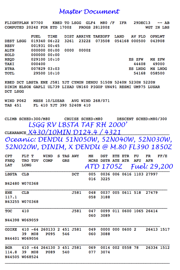
Example master document, oceanic
In the example master document we see a series of waypoints written in the ARINC 24 code: 5150N 5240N 5230N 5220N
The pilot recorded the oceanic clearance as given using the more conventional format: 51° North, 50° West, and so forth.
3
Radial/DME waypoints
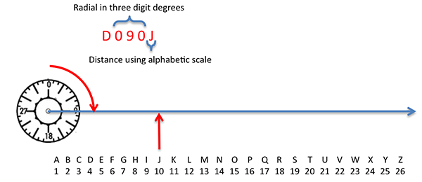
ARINC 424 shorthand Radial/DME
[Technical Manual TM-1-1510-218-10, Table 3-15.]
| Display | Explanation |
| Daaab | D stands for DME arc waypoint |
| aaa stands for the radial that the fix is on from the reference VOR. | |
| b stands for the letter corresponding to the distance from the reference VOR. |
References
(Source material)
Gulfstream G450 Aircraft Operating Manual, Revision 35, April 30, 2013.
Half Degree Grid Waypoints, Jeppesen letter, 30 July 2015.
Technical Manual TM-1-1510-218-10 Army C12C Aircraft Manual, Date Unknown.
Please note: Gulfstream Aerospace Corporation has no affiliation or connection whatsoever with this website, and Gulfstream does not review, endorse, or approve any of the content included on the site. As a result, Gulfstream is not responsible or liable for your use of any materials or information obtained from this site.