If you are flying a circling approach in the United States or anywhere in the world where the approach is based on the older United States Standard for Terminal Instrument Procedures (TERPS) approach radii, be very careful. There are four factors you may not have thought about and each can kill you: (1) Authorized circling approach radii do not consider pressure altitude or winds. (2) Authorized radii exceed the authorized visibility minimums. (3) Reported visibility might not reflect where you intend to fly. (4) Radii and visibility minimums are based on different scales (nautical and statute).
— James Albright

Updated:
2019-05-09
So this is a plea for you to set your personal visibility minimums higher than those on the charts if the approach is based on TERPS and doesn't have the "C" denoting an expanded circling approach area. How high? I can't answer that for you, but I have adopted VFR minimums as my circling minimums.
Also keep in mind the impact of winds could throw out a lot of the math. TERPS will consider winds under some conditions, typically at 25 knots. How often do you see winds much higher than that at circling minimums? Now and then. If those winds are pushing you away from the airport, your obstacle clearance numbers could be jeopardized.
1 — Authorized circling approach radii do not consider pressure altitude or winds
2 — Authorized radii exceed the authorized visibility minimums
3 — Reported visibility might not reflect where you intend to fly
4 — Radii and visibility minimums are based on different scales (nautical and statute)

1
Authorized circling approach radii do not consider pressure altitude or winds
Visibility versus radii paradox
Maximum authorized speeds at each approach category
Aircraft approach category means a grouping of aircraft based on a speed of VREF, if specified, or if VREF is not specified, 1.3VSO at the maximum certificated weight. VSO, and the maximum certificated landing weight are those values as established for the aircraft by the certification authority of the country of registry.
These categories are as follows:
- Category A: Speed less than 91 knots
- Category B: Speed 91 knots or more but less than 121 knots
- Category C: Speed 121 knots or more but less than 141 knots
- Category D: Speed 141 knots or more but less than 166 knots
- Category E: Speed 166 knots or more
Source: 14 CFR 97.3
These speeds are used to determine an aircraft's turn radius to ensure they fit inside the authorized circling approach radius, but they do not specify the pressure altitude used.
More about this: Approach Categories.
Turn radius
The horizontal component of lift will equal the centrifugal force of steady, turning flight. This fact allows development of the following relationships of turning performance:
turn radius
where:
r = turn radius, ft
V = velocity, knots (TAS)
θ = bank angle, degrees
Source: ATCM 51-3, pg. 178
Doing the math for a 25° bank turn and converting V (in knots) to v (in nautical miles per minute) you get a good approximation:
Turn radius (nautical miles) = (nautical miles per minute)2 / 9
More about this: Turn Performance.
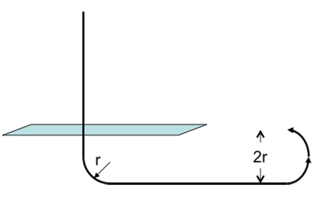
Offsetting twice the turn radius
Remember that for some circling approaches we will need to turn to a downwind which requires we have two radii displacement from the runway, as shown in the diagram. So our objective here is to have the authorized radius exceed the turn diameter.
From these formulas we can see that the authorized radii work perfectly if you were turning the airplane at sea level:
| Category: | C | D |
| Maximum Speed: | 140 | 165 |
| Authorized Approach Radii | 1.7 nm | 2.3 nm |
| TAS / Turn Radius / Diameter / Margin | 141 / 0.61 nm / 1.22 nm / 28 % | 166 / 0.85 nm / 1.70 nm / 26% |
You can maneuver in this airspace with a 26 or 28% margin for error, not bad if the winds cooperate.
Pressure altitude increases TAS, which increase turn radius
True airspeed, coupled with ambient density ratio, produces the same dynamic pressure as EAS, coupled with standard sea level density ratio. That is
TAS2 σ = EAS2 σ0
But σ0 = 1, so:
TAS = EAS √ ( 1/ σ)
Source: Dole, pg. 25
More about this: Properties of the Atmosphere.
Running our table again with several pressure altitudes:
| Category: | C | D |
| Maximum Speed: | 141 | 166 |
| Authorized Approach Radii | 1.7 nm | 2.3 nm |
| TAS / Turn Radius / Diameter / Margin | 141 / 0.61 nm / 1.22 nm / 28 % | 166 / 0.85 nm / 1.70 nm / 26 % |
| PA / TAS / Turn Radius / Diameter / Margin | 5000 / 151 / 0.7 nm / 1.4 nm / 18 % | 5000 / 178 / 0.98 nm / 1.96 nm / 15 % |
| PA / TAS / Turn Radius / Diameter / Okay? | 9000 / 161 / 0.8 nm / 1.6 nm / 6 % | 9000 / 191 / 1.12 nm / 2.24 nm / 3 % |
The higher your MDA, the slimmer your margin for error becomes. Of course with a wind pushing you away from the runway, even the healthier sea level margins could disappear without you knowing it.
2
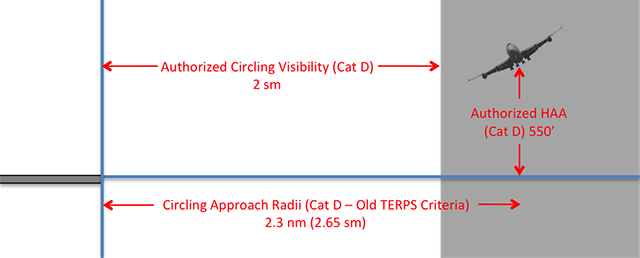
Authorized radii exceed the authorized visibility minimums
It appears a committee at TERPS decided to base their original circling approach radii on aircraft turn radius at maximum category speeds and published that in nautical miles. Then another committee decided to come up with circling visibility minimums and as long as those numbers were less than the radii, that must be good. Of course they published their numbers using statute miles.
The biggest problem here is that airplanes can quickly use up all of that allocated turn radius at the higher end of the airspeed range given each category. They can quickly find themselves maneuvering outside the visibility minimums and lose sight of the runway. The problem is made worse when you realize that maneuvering is done in space measured in nautical miles. The radius number is 15% higher in statute miles.

TERPS, Volume 1, ¶210.c, ¶260.a., and ¶3.3.3.
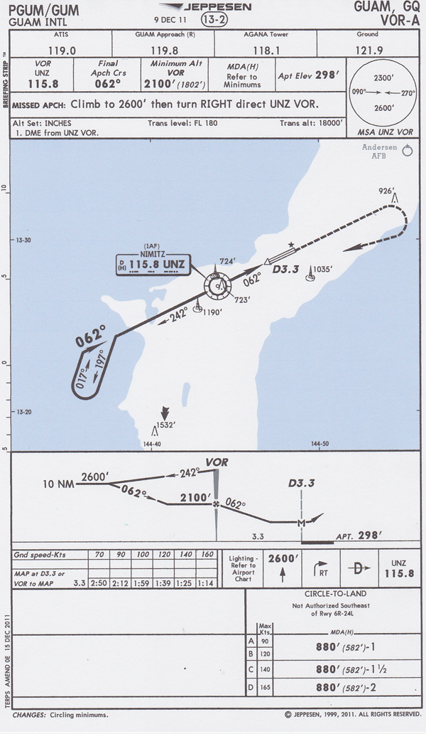
Hanscom Field (KBED) Localizer Runway 11, circle Runway 5, Category D Aircraft.
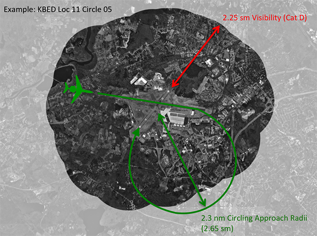
Example circling approach radii versus visibility
Example: Runway 05 at Hanscom Field, Bedford, Massachusetts (KBED) does not have an instrument approach. If the winds or runway closures make Runway 05 your only option, you can expect to be cleared the ILS or LOC Rwy 11, circle to 05. The weather required for a category C aircraft is 800 and 2, and for a category D aircraft is 800 and 2-1/4. Note these visibilities are in statute miles. As of 18 October 2014 this approach into Bedford does not include the expanded circling area of increased minimums found in updated TERPS guidelines.
The airport can be open using this approach down to 2 or 2-1/4 statute miles visibility. We often brief, in a category D aircraft, "I'll stay within 2.3 miles of the airport. That 2.3 nautical miles comes to 2.65 statute miles. That won't work here where the visibility may be down to 2.25 statute miles.
If the winds are 020 / 30, which happens now and then, you may be flying this approach because the crosswinds on Runway 11 exceed your limits. You wouldn't have been able to keep within 2 statute miles on a no wind day, what are your chances with a 30-knot wind blowing you further south?
3
Reported visibility might not reflect where you intend to fly
Prevailing visibility is the greatest visibility equalled or exceeded throughout at least one half of the horizon circle, not necessarily contiguous.
Source: Aeronautical Information Manual, ¶7-1-17.b.
Visibility Sensors
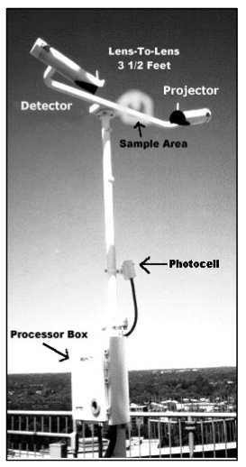
Forward scatter visibility sensor
from ASOS User's Guide, figure 13
- [Testing] supported the premise that only one sensor, located in a representative area, could be used to describe the visibility for an airport area. It was still recognized that sites plagued by advection fog or other visibility discontinuities would require additional sensors. Every airport required a site survey to properly locate the visibility sensor and identify locations that might need additional sensors.
- The location of the visibility sensor(s) was critical. The small sampling volume of the sensor dictated that the sensor be located as near to the area of concern as possible. As a result, most primary visibility sensors were placed near the touchdown zone (TDZ) of the primary instrument runway.
Most airports will have their visibility based on the sensor next to the touchdown zone of the primary instrument runway. The sensor measures visibility at that particular spot and may not reflect the actual visibility within the circling radius of the airport or the approach end of other runways. For more about this, see Automated Weather.
Source: ASOS User's Guide, ¶4.2
4
Radii and visibility minimums are based on different scales (nautical and statute)
| Category: | C | D |
| Authorized Visibility Minimums (sm) | 1-1/2 | 2 |
| Authorized Radius (nm) | 1.7 nm | 2.3 nm |
| Authorized Radius (sm) | 1.96 sm | 2.65 sm |
If we need all the authorized airspace to maneuver we are already outside our visibility minimums and will lose sight of the runway, even if the units of measure matched. But they don't, and we are even further outside.
5
Is the visibility minimum enough?
Missed approach procedures. Each pilot operating an aircraft, except a military aircraft of the United States, shall immediately execute an appropriate missed approach procedure when either of the following conditions exist:
(2) Whenever an identifiable part of the airport is not distinctly visible to the pilot during a circling maneuver at or above MDA, unless the inability to see an identifiable part of the airport results only from a normal bank of the aircraft during the circling approach.
Source: 14 CFR 91, §91.175(e)
Is the visibility minimum high enough to allow you to keep sight of an identifiable part of the airport during a circling maneuver that ends in a stabilized approach at or above the MDA without excessive bank angle? The answer is a resounding no and the answer applies to more than just circling approaches in the United States without the expanded circling area, shown below, Fix of the Future. TERPS criteria are used throughout the world at countries that either adopted our standards rather than develop their own, or where there is or has been a strong U.S. military presence.
The VOR-A to Guam International, for example, is based on TERPS. You can tell that on a Jeppesen chart by the note in the bottom-left corner. Notice also that the circling visibility minimums are based on the old TERPS standard.
6
The fix of the future
For years many of us have been saying the 1.7 Cat C / 2.3 Cat D minimums specified in TERPS were going to kill someone and in 2002 they did. While other factors were involved, had the circling visibility minimums been raised to match a more realistic radii, the accident could have been avoided.
See: Case Study: Air China 129.
The FAA corrected the problem but did not mandate all circling approaches be updated. Chances are the next circling approach in your future will have been based on standard circling approach maneuvering radius. The FAA appears to acknowledge the flaw by adopting expanded maneuvering airspace for future approaches:
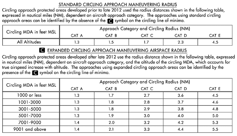
Circling Approach Area Radii, from Aeronautical Information Manual, ¶5-4-20, Figure 5-4-28.
If you take a look at the expanded circling approach maneuvering airspace radius in the table above, you will have a good idea of how much airspace your airplane needs to maneuver for landing for various altitudes and approach categories. I have decided that I am not going to accept a circling approach at visibilities less than what I can maneuver the airplane. The 5001 - 7000 foot line gives me a place to start:
3 or 4 up to 5 . . . I need 3 miles visibility (Cat C) or 4 miles visibility (Cat D) up to an MDA of 5,000 feet.
References
(Source material)
Aeronautical Information Manual
Air Training Command Manual 51-3, Aerodynamics for Pilots, 15 November 1963
Automated Surface Observing System (ASOS) User's Guide, National Oceanic and Atmospheric Administration, March 1998
Dole, Charles E., Flight Theory and Aerodynamics, 1981, John Wiley & Sons, Inc, New York, NY, 1981.
United States Standard for Terminal Instrument Procedures (TERPS), Federal Aviation Administration 8260.3B CHG 25, 03/09/2012