If you fly over the poles under 14 CFR 135, you need to understand everything written below about high latitude operations. It could very well be that you can't legally do what your airplane is physically capable of doing.
— James Albright

Updated:
2020-12-30
Flying over the poles under 14 CFR 91? You still need to understand this stuff, but you might not be prevented from doing something stupid. Me? I would make sure we had all our ducks in line first. What follows will help you do just that.

1
Location

Southern, Northern, and Arctic Control Areas, (Transport Canada Aeronautical Information Manual, Figure 2.3
- The North Polar Area is defined as the entire area north of latitude 78 degrees North.
- The South Polar Area is defined as the entire area south of latitude 60 degrees South.
Source: Advisory Circular 120-42B, ¶601.
The worst magnetic compass performance is probably in the center of the Northern Control Area, home to the magnetic North Pole. This position creates a notch in the circle of magnetic unreliability, often called a "key hole." Charts should be checked for the presence of a "T" denoting the use of True Heading instead of Magnetic. Some aircraft automatically switch to True based on airway designation or latitude. The G450, for example, automatically switches above N73° or S60° latitude.
Canadian Regulations
- Controlled airspace within the High Level Airspace is divided into three separate areas. They are the Southern Control Area (SCA), the Northern Control Area (NCA) and the Arctic Control Area (ACA).
- Pilots are reminded that both the NCA and the ACA are within the Northern Domestic Airspace; therefore, compass indications may be erratic, and true tracks are used in determining the flight level at which to fly. In addition, the airspace from FL 330 to FL 410 within the lateral dimensions of the NCA, the ACA and the northern part of the SCA has been designated CMNPS airspace.
Source: Transport Canada Aeronautical Information Manual, ¶ 2.6
What we used to call "polar ops" is now "high latitude operations." The definition depends on your source of information but can be summarized as follows:
- The northern and southern poles.
- The Canadian Northern Domestic Area (NDA). The NDA includes the Northern Control Area (NCA), the Arctic Control Area (ACA) and the Area of Magnetic Unreliability (AMU). The NDA, NCA and ACA are depicted on Canadian HI en route charts and encompass the northernmost Canadian airspace.
2
Documentation / certification
Operations in the North Polar Area.] After February 15, 2008, no certificate holder may operate an aircraft in the region north of 78° N latitude (“North Polar Area”), other than intrastate operations wholly within the state of Alaska, unless authorized by the FAA. The certificate holder's operation specifications must include the following:
- The designation of airports that may be used for en-route diversions and the requirements the airports must meet at the time of diversion.
- Except for all-cargo operations, a recovery plan for passengers at designated diversion airports.
- A fuel-freeze strategy and procedures for monitoring fuel freezing for operations
- A plan to ensure communication capability for operations in the North Polar Area.
- An MEL for operations in the North Polar Area.
- A training plan for operations in the North Polar Area.
- A plan for mitigating crew exposure to radiation during solar flare activity.
- A plan for providing at least two cold weather anti-exposure suits in the aircraft, to protect crewmembers during outside activity at a diversion airport with extreme climatic conditions. The FAA may relieve the certificate holder from this requirement if the season of the year makes the equipment unnecessary.
Source: 14 CFR 135, §135.98
All approvals for operations into AMUs are granted by issuing OpSpec B040, and by adding that area of en route operation to the standard OpSpec B050. A checklist for operations in AMUs is available in the guidance subsystem in association with OpSpec B040.
Source: FAA Order 8900, Volume 4, Chapter 1, §5, ¶4-103.D]
Crews operating under 14 CFR 135 require operations specification approval (B040 and B050).
Crews operating under 14 CFR 91 should consider the many challenges involved and the potential safety risks illustrated below.
3
Equipment
Certificate holders must have at least two cold weather anti-exposure suit(s) for the crewmembers on the airplane if outside coordination by a crewmember at a diversion airport with extreme climatic conditions is determined to be necessary. The certificate holder may be relieved of this requirement based on seasonal temperatures that would render the use of such suits unnecessary. This determination must be made with concurrence of the CHDO.
Source: Advisory Circular 135-42, Appendix 3, ¶3.f.
This isn't much of a list; you would be wise to consider adding the requirements of Advisory Circular 120-42B, which do not restrict 14 CFR 135 and 91, but offer sound operating practices.
- Fuel quantity indicating system (FQIS), including the fuel tank temperature indicating system;
- APU (when the APU is necessary for an airplane to comply with ETOPS requirements), including electrical and pneumatic supply to its designed capability,
- Autothrottle system;
- Communication systems relied on by the flight crewmember to satisfy the requirement for communication capability; and
- Except for all-cargo operations, an expanded medical kit to include automated external defibrillators (AED).
Source: Advisory Circular 120-42B, ¶603.b.(5)
MEL
Before receiving approval to conduct polar operations, a certificate holder must review their MEL for such operations and should amend their MEL. The following systems and equipment should be addressed in the MEL based on specific needs applicable to this operation.
(1) Fuel Quantity Indicating System (to include a fuel tank temperature indicating system).
(2) Communication system(s) needed for effective communications by the flight crewmember while in flight.
(3) Expanded medical kit.
Source: Advisory Circular 135-42, Appendix 3, ¶3.c.
4
Training
Before conducting polar operations, certificate holders must ensure that flight crewmembers are trained on any applicable passenger recovery plan used in this operation. Certificate holders should also ensure that flight crewmembers are trained on the following items, which should be included in a certificate holder's approved training programs:
(1) Atmospheric pressure at Field Elevation/Barometric pressure for Local Altimeter Setting and meter/feet conversion issues (flight crewmember training).
(2) Training requirements for fuel freeze (maintenance and flight crewmember training).
(3) General polar-specific training on weather patterns and aircraft system limitations (flight crewmember training).
(4) Proper use of the cold weather anti-exposure suit, if required (flight crewmember training).
(5) Radiation exposure (see AC 120-61A, In-Flight Radiation Exposure).
Source: Advisory Circular 135-42, Appendix 3, ¶3.e.
5
Communications issues
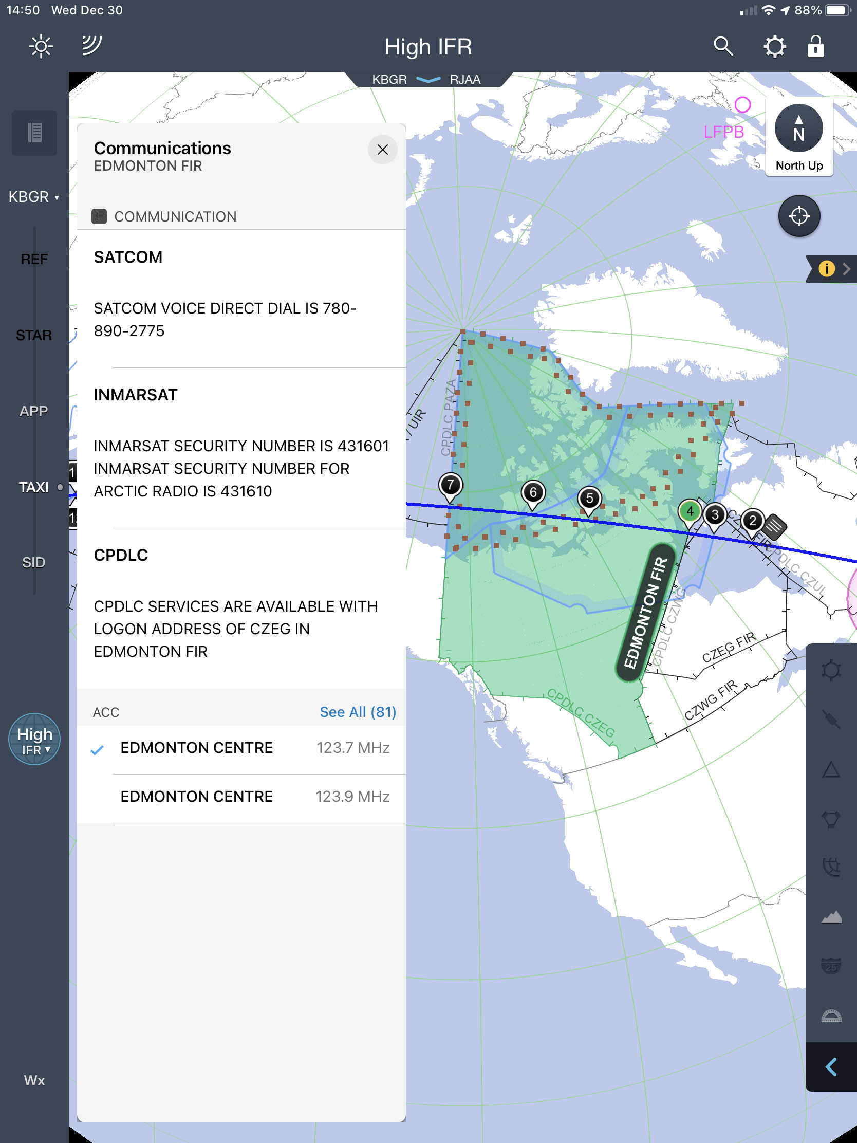
Edmonton FIR communications, from JeppFD
The FAA recognizes the limitations of satellite communications (SATCOM) in the North Polar Area above this latitude, and in such an area an alternate communication system such as HF voice or data link is to be used. The relatively short period of time that the flight is above latitude 82 degrees North in relation to the total planned flight time is a small fraction of the total flight. The ability to use SATCOM for all other portions of the flight, which for some routes could be longer than 15 hours duration, is advantageous to the flight. For flights above 82 degrees North latitude, the operator must also ensure that communications requirements can be met by the most reliable means available, taking into account the potential communication disruption due to solar flare activity. The same philosophy and commensurate requirements apply for ETOPS in the South Polar Area.
Source: AC 120-42B, ¶303.c.(7)
VHF, HF, INMARSAT, CPDLC
You can find frequencies, phone numbers, and CPDLC addresses on en route charts. To do this in JeppFD, you scroll and zoom to the region in question and tap on any point away from the existing route or waypoints. You should get a flag with the FIR name. Click that to get the FIR contact information, as shown in the photo.
I am told that VHF is sparse, HF quality is generally good, though signals may be impacted by solar activity. You may need to use either AM, USB or LSB to achieve the best clarity.
Inmarsat
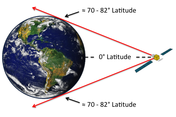
INMARSAT Line of Sight
Keep in mind that Inmarsat satellites are geostationary, generally near the equator. They may not have good line-of-sight near the poles. Geosynchronous satellites, such as Iridium, have better coverage at the poles.
6
Navigation issues
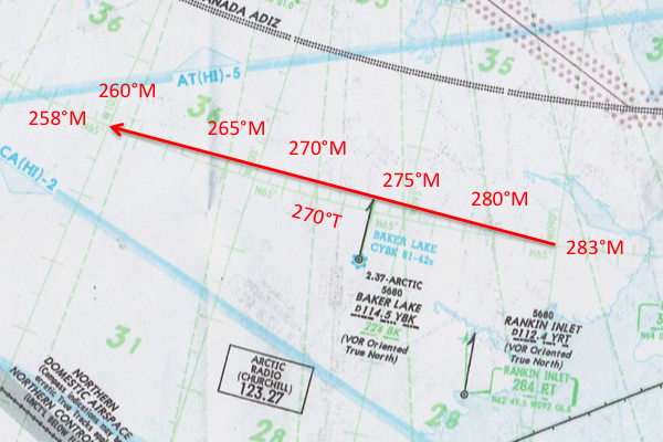
Magnetic Variation Convergence Example
Magnetic Variation and Convergence of the Meridians
The following from an outdated navigation manual that still makes sense:
- Conventional magnetic compasses sense magnetic direction by detecting the horizontal component of the earth's magnetic field. Since this horizontal component vanishes near the magnetic poles, magnetic compasses are highly unreliable and unusable in an area approximately 1,000 NM from each magnetic pole. Within these areas, air navigation tasks are further complicated by very rapid changes in magnetic variation over small distances. For example, when flying between the magnetic North Pole and the true North Pole, a heading of true North results in a magnetic heading of South (a magnetic variation of 180 degrees).
- Since these two major AMUs also occur near the earth's geographic poles, the convergence of the meridians also presents additional directional complications. When flying "great circle" courses at latitudes greater than 67 degrees, convergence of the meridians can create rapid changes in true headings and true courses with small changes in aircraft position. As a result, relatively small errors in determining the aircraft's actual position can produce very large errors in determining the proper heading to fly and maintain the assigned flight path. When even small errors occur, very large navigation errors can develop over extremely short distances. An extreme example of this phenomenon occurs at the earth's geographic North Pole. Flight in any direction from the exact pole is initially due South (that is, the direction to Russia or the United States is South).
The example chart illustrates the rapid change in magnetic heading over a relatively short distance.
True Heading
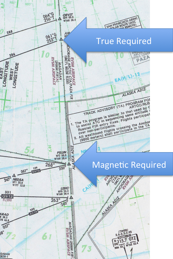
True vs. Magnetic Example,
(Jeppesen Airway Manual AP(HI))
Navigating near the poles presents several issues not found anywhere else in the world. Because of these issues, the only acceptable method of navigating through the NCA and high latitude region is through the use of long-range navigation systems using inertial and GPS based FMS systems referenced to True North only. Back when I was a Strategic Air Command trained killer, our navigators would use grid navigation to head from here to there and I do believe we got lost a few times.
Other methods of navigation in the NCA are impractical or unreliable because of the inherent limitations of magnetic compasses near the magnetic and geographic North Poles, and because of the geometric problem caused by meridian convergence.
Some aircraft make the switch automatically by reference to latitude or airway, while for other the switch must be made manually. You need to dive into your aircraft manuals to find out.
GPS Navigation
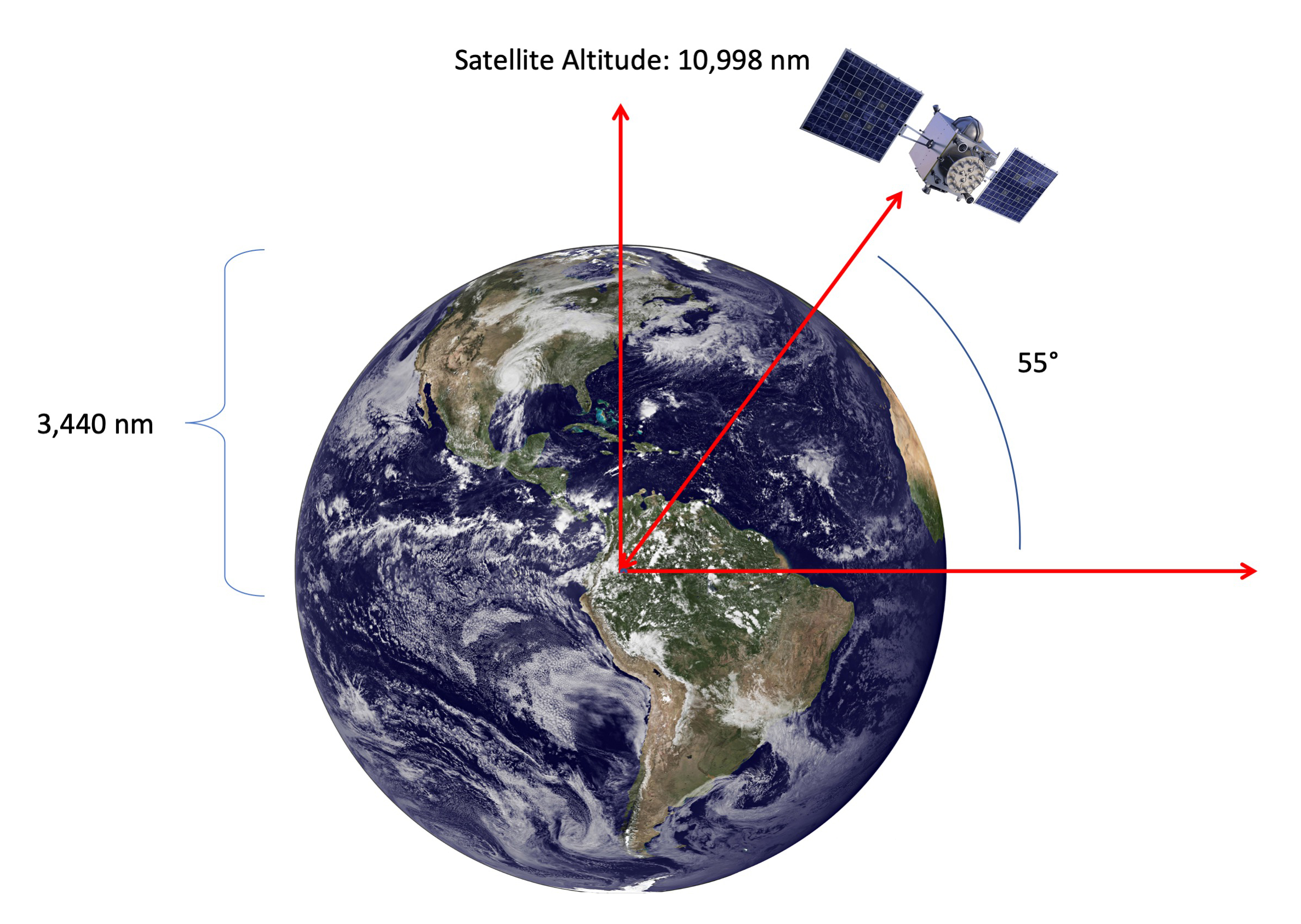
GPS Satellite Line of Sight
Each GPS satellite traces a track over the earth from 55° North to 55° South every twelve hours. At their maximum latitudes they are actually "looking down" on the poles:
Of course you have no guarantee you will have at least one satellite that high in its orbit. In order to have line of sight on the pole, a satellite would have to be at least 39° latitude:
I've not found anything in writing that tells you there will always be at least four satellites above 39° North and 39° South, but it appears so. You should have a good GPS position at either pole.
More about this: GPS.
7
Temperature issues
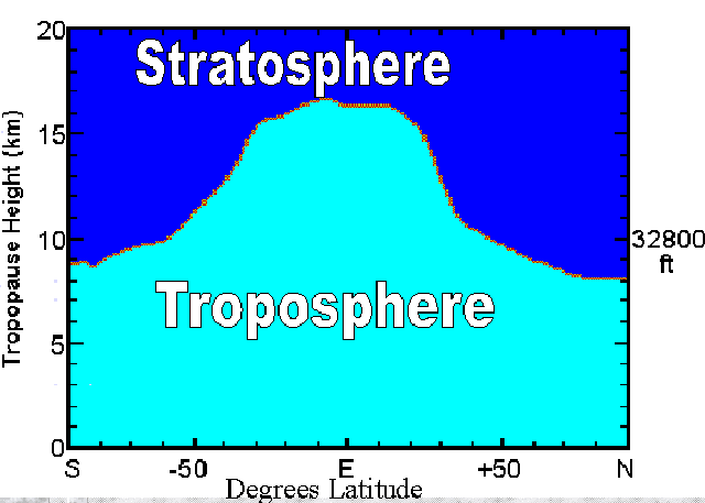
Tropopause Height, (Geerts and Linacre
Tropopause Height and ISA
- The height of the tropopause depends on the location, notably the latitude, as shown in the figure on the right (which shows annual mean conditions). It also depends on the season.
- At latitudes above 60°, the tropopause is less than 9-10 km above sea level; the lowest is less than 8 km high, above Antarctica and above Siberia and northern Canada in winter. The highest average tropopause is over the oceanic warm pool of the western equatorial Pacific, about 17.5 km high, and over Southeast Asia, during the summer monsoon, the tropopause occasionally peaks above 18 km. In other words, cold conditions lead to a lower tropopause, obviously because of less convection.
- Deep convection (thunderstorms) in the Intertropical Convergence Zone, or over mid-latitude continents in summer, continuously push the tropopause upwards and as such deepen the troposphere.
- On the other hand, colder regions have a lower tropopause, obviously because convective overturning is limited there, due to the negative radiation balance at the surface. In fact, convection is very rare in polar regions; most of the tropospheric mixing at middle and high latitudes is forced by frontal systems in which uplift is forced rather than spontaneous (convective). This explains the paradox that tropopause temperatures are lowest where the surface temperatures are highest.
Source: Geerts and Linacre
The tropopause at the poles is lower than at the equator; that means the altitudes where most polar-capable aircraft cruise is warmer. Knowing this, altitude selection may not be straight forward.
More about this: Properties of the Atmosphere.
Surface Temperatures
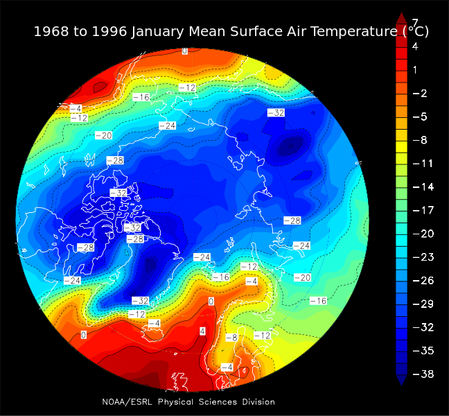
North Pole January Mean Temperatures, (Wikimedia Commons)
If a descent into lower altitudes is required, fuel freezing and other aircraft systems limitations can become issues. If an emergency landing is required, surface temperatures can be life threatening.
Fuel Freezing
Fuel Freeze Strategy and Monitoring Requirements for Polar Operations. Certificate holders must develop a fuel freeze strategy and procedures for monitoring fuel freezing for operations in the North Polar Area. A fuel freeze analysis program in lieu of using the standard minimum fuel freeze temperatures for specific types of fuel may be used. In such cases, the certificate holder's fuel freeze analysis and monitoring program for the airplane fuel load must be acceptable to the FAA Administrator. The certificate holder should have procedures for determining the fuel freeze temperature of the actual fuel load on board the airplane. These procedures relative to determining the fuel freeze temperature and monitoring the actual temperature of the fuel on board should require appropriate levels of coordination between maintenance and the flight crewmember.
Source: Advisory Circular 135-42, Appendix 3, ¶3.c.
Should fuel temperatures approach the aircraft’s freezing limit you should consider:
- Climbing or descending into a level of warmer air,
- Altering the route into a region of warmer air, and/or
- Increasing cruise airspeed (Fuel temperatures should increase approximately one degree for every .02 increase in Mach speed)
Your flight planning vendor should provide a temperature chart to help you plan for these contingencies. Remember, any changes in flight level, speed or route must be coordinated with ATC.
For more on weather at high latitudes, see: Arctic Weather.
8
Polar radiation issues

Solar Flare, (Wikimedia Commons)
Less radiation will be received on a lower-latitude flight because of the greater amount of radiation shielding provided by the Earth’s magnetic field. This shielding is greatest near the equator and gradually decreases to zero as one goes north or south. Galactic cosmic radiation levels over the polar regions are about twice those over the geomagnetic equator at the same altitudes. Because solar particle peak energies are much lower than galactic particle peak energies, solar cosmic radiation dose rates are negligible near the geomagnetic equator.
Source: Advisory Circular 120-61B, ¶6.a.
- Space radiation on the ground is very low, but increases significantly with altitude. At 30,000 to 40,000 feet, the typical altitude of a jetliner, exposure on a typical flight is still considered safe – less than a chest X-ray.
- Exposure is considerably higher, however, over the Earth's poles, where the planet's magnetic field no longer provides any shielding. And with a thousand-fold rise in commercial airline flights over the North Pole in the last 10 years, exposure to radiation has become a serious concern.
- A study by Mertens of polar flights during a solar storm in 2003 showed that passengers received about 12 percent of the annual radiation limit recommended by the International Committee on Radiological Protection. The exposures were greater than on typical flights at lower latitudes, and confirmed concerns about commercial flights using polar routes.
- People who work on commercial airline flights are technically listed as "radiation workers" by the federal government – a classification that includes nuclear plant workers and X-ray technicians. But unlike some others in that category, flight crews do not quantify the radiation they are exposed to.
Source: NASA Study, Michael Finneran
Flights in the Polar Region at typical business jet operating altitudes are well above the tropopause where much of the atmospheric protection from solar storms is lost, increasing crew and passenger exposure to solar radiation.
For example, one New York-Tokyo flight during a solar storm could expose the passengers and crew to the normal annual exposure (1mSv) of someone who remained on the surface. If an S4 solar storm is active or predicted, polar operations are generally considered not suitable at any altitude, while operations at FL 310 or below are considered acceptable in S3 storm conditions.
9
Alternate airports
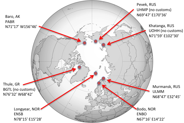
Arctic Alternates
Before each flight, certificate holders must designate alternate airports that can be used in case an en route diversion is necessary. The airplane should have a reasonable assurance that the weather during periods when the certificate holder would need the services of the airport are within the operating limits of the airplane. The airplane should be able to make a safe landing and maneuver off the runway at the diversion airport. In addition, those airports identified for use during an en route diversion should be capable of protecting the safety of all personnel by allowing:
(1) Safe offload of passengers and crewmember during possible adverse weather conditions;
(2) Providing for the physiological needs of the passengers and crewmember until a safe evacuation is completed; and
(3) Safe extraction of passengers and crewmember as soon as possible (execution and completion of the recovery should be within 12 to 48 hours following landing).
Source: Advisory Circular 135-42, Appendix 3, ¶3.a.
Operators are expected to define a sufficient set of polar diversion alternate airports, such that one or more can be reasonably expected to be suitable and available in varying weather conditions (AC 120-42A, Extended Range Operation With Two-Engine Airplanes (ETOPS), provides additional guidance for two-engine airplanes).
Source: FAA Order 8900, Volume 4, Chapter 1, §5, ¶4-103.E.
A recovery plan is required that will be initiated in the event of an unplanned diversion. The recovery plan should address the care and safety of passengers and flight crew at the diversion airport and include the plan of operation to extract the passengers and flight crew from that airport.
Source: FAA Order 8900, Volume 4, Chapter 1, §5, ¶4-103.G.
The requirements for the passenger recovery plan are quite extensive and must be detailed for each airport listed as a possible alternate airport.
More on this: Advisory Circular 135-42, Appendix 3, ¶3.b.
There aren't many airports with paved runways in the Arctic, and many of those do not have regular airline service or customs. If you are flying under 14 CFR 135 your Operations Specification approval will require a list of alternates and a plan for getting passengers from the alternates within 48 hours.
Even if you do find a suitable alternate with a paved runway, consider what services are available. If, for example, you have a passenger suffering a stroke, will you be better off continuing six hours to your destination or landing at a remote airfield that is days away from the nearest capable healthcare facility? The same can be said for maintenance. If you have to land as soon as possible, obviously do that. But remember to consider the events following landing when weighing your decision.
References
(Source material)
14 CFR 135, Title 14: Aeronautics and Space, Operating Requirements: Commuter and On Demand Operations and Rules Governing Persons on Board Such Aircraft, Federal Aviation Administration, Department of Transportation
Advisory Circular 120-42B, Extended Operations (ETOPS and Polar Ops), 6/13/08, U.S. Department of Transportation
Advisory Circular 120-61B, In-flight Radiation Exposure, 11/21/14, U.S. Department of Transportation
Advisory Circular 135-42, Extended Operations (ETOPS) and Operations in the North Polar Area, 6/10/08, U.S. Department of Transportation
FAA Order 8900.1
Geerts, B. and Linacre, E, The Height of the Tropopause, University of Wyoming, Atmospheric Science 11/97.
Transport Canada Aeronautical Information Manual, Effective 0901Z, October 8, 2020