The Blue Spruce Routes have always been an academic exercise for me, something I've never done but have had to be prepared to do in case something goes wrong. But for others it is the way the North Atlantic is crossed.
— James Albright

Updated:
2017-06-22
Everything that follows is from Jason Herman, a CJ pilot turned airline pilot who keeps his hand in smaller jets.

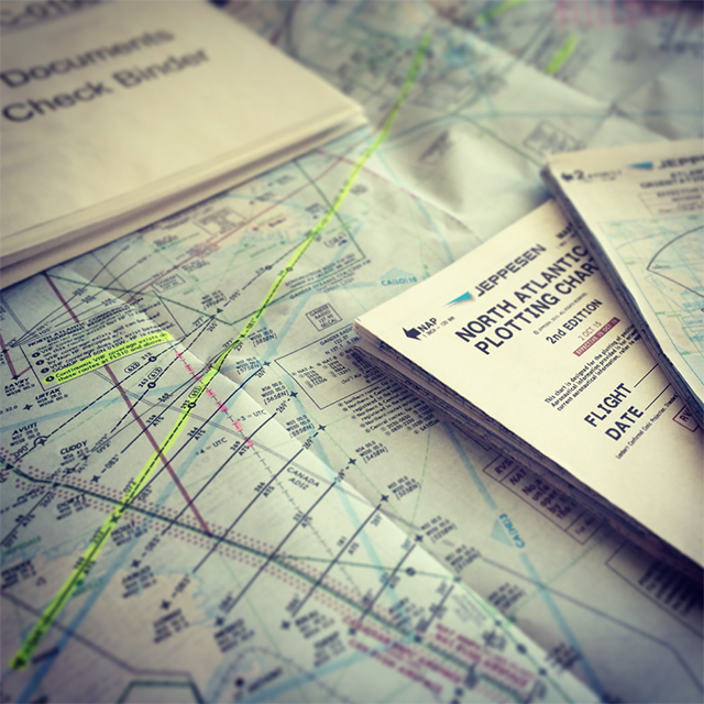
Photo: Plotting charts, from Jason Herman.
Whether you fly a long range aircraft internationally or a shorter range light jet, you may be familiar with the ‘Blue Spruce Routes’ which cross the Atlantic Ocean toward the northern portion of North Atlantic High Level Airspace (HLA, formerly MNPS). If you are flying a light jet with shorter range capability, the Blue Spruce Routes are likely your only option to cross the North Atlantic. However, even long range aircraft occasionally have to use these routes due to navigation or equipment failure restricting their operation from more optimized direct routes through the middle of HLA. Inoperative or loss of dual Long Range Navigation Systems (LRNS) or High Frequency radio equipment may cause these routes to be the only option to make a North Atlantic Crossing.
This article will focus principally on crossing the North Atlantic with a tech/fuel stop in Iceland in a light jet, an aircraft that may not be truly designed or equipped for regular oceanic operations unlike today’s long range fleet. Crossing the North Atlantic in a short to medium range aircraft is not necessarily difficult, but does require a fair amount of pre-trip preparation, logistics, and planning.
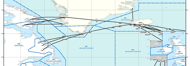
Photo: Blue Spruce Routes, from NAT Doc 007 (Figure 4), from Jason Herman.
Logistics and Pre-Trip Preparation
Most light jet aircraft are well designed and equipped to fly a variety of missions over land and sea in a concentrated geographic area. For example, an airplane based in Van Nuys, CA may routinely fly throughout North America, the Gulf of Mexico, Bahamas, Caribbean, and Central America. Seldom would this type of aircraft make routine trips across the North Atlantic or down to South America. It can certainly be done, but is somewhat outside the scope of normal operations.
Since this type of aircraft is normally operated in well-known centralized areas, there are a number of logistical considerations when planning a trip across the North Atlantic. The following will discuss many of these items that need to be addressed well prior to launching across the pond.
FMS/Navigation Database
Many short range jet aircraft subscribe to a single area ‘Americas’ Database which contains navigation data for a limited geographic area. For example, a Rockwell Collins Type 6 or 7 database for the Americas does not contain navigation data east of Iceland. If you are heading past 10 degrees West longitude, you may need to obtain a ‘World’ database, or for older FMS suites which have limited storage capability, obtain ‘Atlantic’ and/or ‘Europe’ databases. Newer FMS suites can hold the entire world in a single database while older systems may require you to obtain and switch databases during your journey. If this applies to the FMS in your aircraft, how do you plan to load and switch the database to ensure continuous coverage? Some Nav Database providers will offer one free ‘World’ database per year so be sure to check before you give them your credit card info.
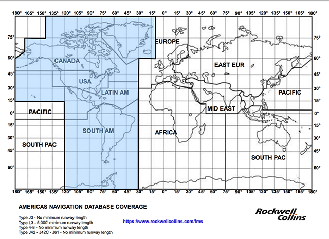
Photo: Rockwell Collins Jeppesen/Lufthansa Type 3-8 ‘Americas’ Coverage Map, from Jason Herman.
Terminal and En route Charts
Electronic charting solutions have made this issue much easier to solve. If you normally subscribe to the USA, Canada, and Latin America regions, you will need to obtain an additional chart subscription for your journey across the pond. This can be easily procured through a one time ‘Trip Kit’ which providers like Jeppesen will kindly offer you for a decent price. Electronic charts are easy to obtain and download but one must also consider Chart effectivity schedules and means to download new Charts and load them into the aircraft database or EFB/iPads. Additionally, Jeppesen will include a North Atlantic Orientation Chart, 5-pack of Plotting Charts, and Low/Hi En route Charts with an ‘Atlantic’ region trip kit.
When Jeppesen adds a new region to your subscription, it is quite easy to download and use these charts on your iPad instantly. However, in aircraft which have Class 3 type EFB charting solutions on installed aircraft displays (MFDs), you may need to obtain individual coverage access codes to ‘unlock’ the new regions until your subscription code is embedded into the new chart file with the appropriate subscription access. This requires a quick phone call to Jeppesen Tech Support but is a critical step to ensure you have access to digital charts in the cockpit before launching, if equipped.
Another consideration is how you plan to store the nearly 50 some-odd paper en route charts. One or two traditional leather Jeppesen Airway Manual binders will typically do the trick.
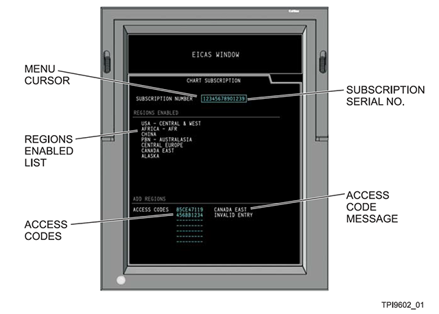
Photo: Chart Subscription Page, Proline 21 for CJ4 Manual (Figure 7-44), from Jason Herman.
Orientation and Plotting Charts
For those planning to plot routes and positions by hand (a really good idea for the first or second crossings), you may want to consider obtaining Plotting Charts ahead of your trip kit to practice with and familiarize yourself with the region. A North Atlantic Orientation Chart and pack of 5 Plotting charts from Jeppesen will only set you back about $40 with tax and shipping. Well worth the cost for advanced planning and preparation. A set of colored pens (Red, Green, Blue) and highlighters are also helpful.
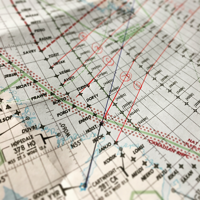
Photo: Plotting chart, from Jason Herman.
Life Raft Rental
Most light jet aircraft do not have a life raft(s) installed in the aircraft. If you already own a life raft, take care to ensure you have the proper survival equipment per 14 CFR 91.509(b) required to accompany the raft, ensure re-certification is still valid (usually required every year), and that a portable self-buoyant, water-resistant ELT is properly registered to the aircraft with a valid 24/7 emergency contact. The last part also holds true for the aircraft ELT registration which is required to be updated every 2 years.
Letters of Authorization
Most light jets will have Letters of Authorization from the FAA for RVSM and MMEL as MEL. Over the North Atlantic, additional LOAs may be required with the most notable being B039 for North Atlantic HLA authorization:
- A153: ADS-B Out Operations Out of U.S. – Designated Airspace (May be required in more countries in the future)
- B034: IFR Class I Terminal and En route Navigation Using RNAV Systems (P-RNAV for European RNAV SIDs/STARs)
- B036: Oceanic and Remote Continental Navigation using Multiple Long Range Navigation Systems M-LRNS (RNP 4 / RNP 10)
- B054: Class II Navigation Using Single Long-Range Navigation System (S-LRNS)
- B039: Operations in North Atlantic High Level Airspace (NAT HLA)
Significant lead time may be required (6+ months), in addition to an International Operations Manual, and even a Tabletop Exercise conducted by an FAA Special Area of Operations (SAO) specialist. The NBAA Domestic Operations Committee and Part 135 Subcommittee are actively working with FAA/AFS-470 to clarify Tabletop requirements and learn how these standards are meant to be applied to new and existing operators. Stay tuned to NBAA media for future info on these efforts.
Insurance Coverage
While many light jets are insured on a Worldwide policy, some are not, and for those that are, additional endorsements may be required for certain countries in Europe. Reach out your Insurance Broker to confirm with your Underwriter any additional insurance requirements when heading across the pond.
International Handlers
Missions from the United States to Canada, Mexico, and the Caribbean may not always require full international and flight planning support. However, when venturing outside these regions, you may want to consider the assistance of a fully qualified flight planning company. They can provide not only flight plan and weather info, but assist in arranging customs/immigration, ground handling, fuel, hotel/crew transportation logistics, and much more. Flight planning services can also offer sample flight plans well in advance of your trip to allow you the opportunity to become familiar with the format and layout of their materials (free of charge) which can differ significantly from what you may currently be used to. Many providers are also happy to customize a format which works best for you and your operation.
Once you make the trip once or twice, you may realize that crossing the pond without the full support of an international provider is certainly doable with a little extra preparation, time, and coordination with local airport officials and service providers. EuroFPL.eu is an excellent resource for flight planning, filing, and IFPS (route) validation in Europe for a pretty low financial commitment. If you decide to do most of the flight planning and handling on your own, be sure to send all of your aircraft, crew, and passenger documents to the airport/FBO ahead of time to avoid any hassles when you arrive.
Satellite Phone (SatPhone)
If your aircraft has a SatPhone, when is the last time you checked to make sure it had an active subscription plan and that it worked? When you start venturing far far away from home base, it is comforting to pick up the phone and call someone if needed when things change. Last minute weather diversions in Iceland and throughout Europe can be stressful but a little bit easier if there is someone on the other end of a properly functioning SatPhone that can help you out in a pinch. I speak from experience on this item as we had to make a last minute weather diversion once from our destination in Asturias, Spain (LEAS) to Santander (LEXJ) after the weather forecast which predicted MVFR quickly turned to 150 meters (500 feet) of visibility in thick fog. A phone call back to the States via SatPhone quickly got the ball rolling with customs and handling at the new landing field.
Calibrated Mach Chart
Over the North Atlantic, oceanic clearances are flown at a constant True Mach number which may differ from indicated Mach in your aircraft. Check your AFM to make the conversion if required. It can be helpful to print this chart and tape it to the panel. An extra reminder never hurts. If the chart converts a whole indicated Mach number to a Calibrated Mach number, you may want to reverse engineer a new chart that goes the other way so it is easier to reference and fly. Since a constant True Mach number must be flown, not a constant Indicated Mach, a new chart clearly adds value.
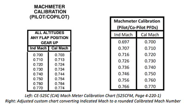
Photo: Mach Meter Calibration Chart, from Jason Herman.
Datalink and Equipment Mandates
As Phase 2B and Phase 3 of the North Atlantic Datalink Mandate approaches, verify your aircraft is appropriately equipped for these new requirements. While TCAS 7.1 is already required for aircraft operating in Europe in addition to an enhanced Mode-S transponder and 8.33 kHz spacing, additional Datalink Mandates are coming down the pipe. Starting in December 2017, FANS 1/A with ADS-C and CPDLC capability will be required from FL 350-FL 390 throughout the entire NAT HLA airspace. Starting in January 2020, this equipment will be required at and above FL 290 throughout the entire NAT HLA.
If your aircraft only has GPS for Long Range Navigation (no Inertial Navigation Units), check your AFM for any required Fault Detection Equipment (FDE) and/or GPS/RAIM Predictions to be completed prior to flight. The FAA also has a 24 Hour RAIM Prediction website with graphical maps.
HF Radio is not required at and above FL 310 on the Blue Spruce Routes. You may be able to rent an HF radio if your aircraft is provisioned for it, but it is likely not worth the cost unless your aircraft has the range to fly from Goose or Gander all the way across the Shannon on a normal NAT random route south of the Blue Spruce Routes.
Medical Certificate Duration/Expirations
Most pilots who stick close to the USA are not aware of the EASA interpretation of Medical Certificate expirations. Calendar months are not used to determine medical certification duration/expiration. If your medical certificate was issued on August 17, 2017, be sure to have a new medical in hand before you leave for Iceland/Europe on August 12, 2017 even if you plan to return before the end of the month.
International Procedures Training
If this is your first crossing, you will want to participate in a very thorough international procedures course. In fact, it may be required in a number of countries you plan to visit or to obtain LOA B039. Prepare to take a course well in advance of your Eastward journey. If you really want to get a head start, check out International Operations for much of the info you may need. Also check out the many other resources available from ICAO and FAA including the NAT Document 007 which outlines Operating Procedures throughout the North Atlantic.
Another trick you may want to consider to get yourself into the Oceanic mindset is to practice calculating Equal Time Points (ETPs) during long domestic trips. Imagine you are flying from Point A to Point B with no land underneath you. Use your departure and destination airport, plus wind forecasts to calculate your Maintain Level, Depressurization, and Engine Inoperative ETPs. This will make calculating ETPs on the fly just before navigating over the ocean a breeze.
Cell Phone Plan
If you do not travel regularly to this part of the world, you may want to look into your cell phone plan/provider to ensure coverage where you will be traveling to. Generally speaking, there is good coverage in both Keflavik and Reykjavik, Iceland as well as mainland Europe.
Contract Fuel Options
Reach out to your contract fuel providers and obtain quotes for each of the stops you plan to make. Retail may be cheaper in some locations, but more expensive in others. Contract providers make it easy in that they will often convert the price for fuel from local currency and liters to USD per Gallon. Make sure you are comparing apples to apples when it comes to currency and unit of measurement, otherwise you may not make a fully optimized financial decision when it comes to fuel payment.
Maintenance/OEM Support
Maintenance support is limited in Iceland and could also be lacking throughout some of the areas you plan to visit in Europe. Coordinating with nearby service centers and maintenance support prior to your trip will provide a good resource should anything break on the road. Establishing contact with the Manager of nearby service centers may not be a bad idea either, so they know who you are, where you are flying, what type of aircraft you are operating, and establish a point of communication should you need their assistance during your journey. Having a contact name and phone number to call when things go wrong can be a big timesaver in addition to having a general idea of where the service centers are located in Europe.
Departing Canada for Iceland
Most light jet aircraft will plan to tech stop in either Gander (CYQX) or Goose Bay (CYYR) in Northeastern Newfoundland Canada. Goose is a good stop with excellent services, approaches, catering, and fuel. Goose Bay Tower will coordinate your oceanic clearance with about 5 or 10 minutes notice and have you on your way.
One consideration when stopping for fuel near the Oceanic boundary is ensuring you can reach the entry fix at the assigned level and speed. Departing Goose Bay to any of the oceanic entry points is only 140 – 160 nautical miles. Depending on your requested cruising level, that may be difficult given the traditionally high temperatures aloft over the North Atlantic (ISA+10 to ISA+20). Speaking of high en route temperatures over the Atlantic, your light jet that normally rockets up to FL 450 may lose steam in the mid-to-high 30’s. A cruising level of FL 410 (or FL 430 if light) may be more realistic for the crossing, at a slightly slower-than-normal Mach. If you are used to leveling off at FL 450 and accelerating from M.73 up to M.76 or M.77 over the following hour, that will likely not work over the ocean. Plan a conservative cruise level and speed, even if it is lower and slower than you are normally used to flying. It is always better to ask to go higher and faster than to under deliver on your cleared/promised level/speed. If you miss your assigned level and/or speed, you may have to make a 360 degree turn to gain altitude or speed prior to Oceanic entry which is no fun, adds time to your flight plan, and changes your nav log calculations.
For aircraft that have the range to fly from Goose direct to Reykjavik or Keflavik, this is certainly preferred as you can completely avoid Narsarsuaq Greenland all together which is notoriously known for ever changing weather, limited services, and only fair instrument approaches. Shorter range aircraft will have to make the stop regardless so advanced planning is certainly recommended to confirm fuel, weather, and brief contingency options.
It is not uncommon to experience a lot of traffic over the Blue Spruce Routes when lighter northerly winds push the Westbound NAT OTS (Tracks) over Greenland during the morning hours. The usually sparse airspace can become dense with westbound airline traffic pretty quickly. Use caution if ATC issues a reroute as this can lead to a strong potential to commit a Gross Navigational Error (GNE). Utilize a standard method of cross-checking between pilots to ensure the correct waypoints are loaded properly into the FMS. Post position checks and plots are equally important after each fix.
For those aircraft not equipped with HF radio, good VHF coverage exists above FL 310 through extended range VHF transmitters on the Eastern Canadian Seaboard, Greenland, and Iceland. One of the most common ‘Blue Spruce Routes’ follows a course from YYR VOR to KEF VOR in Iceland. Along this route, you will note that the North Atlantic Orientation Chart confirms that continuous VHF coverage exists along this route at/above FL 310.
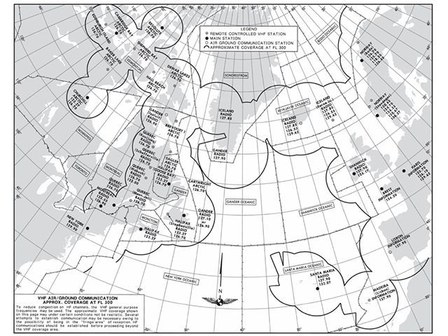
Photo: VHF Coverage Area Map over the North Atlantic, provided by Jeppesen, from Jason Herman.
Departing Goose Bay, there are typically only 3 position reports to make to Gander Radio across the Atlantic. Oceanic entry, at 50W, and at 40W. Passing the southern tip of Greenland, the next report will be with Iceland Radio but depending on Surveillance, you may be switched to Reykjavik Control and radar identified prior to your 30W report. Iceland ATC is working to equip this area with ADS-B surveillance, so some of these reports may be eliminated in the future. There is a large polygon shaped area of ‘ATS Surveillance’ Airspace over Greenland which may contain ADS-B coverage but has not as of November 2016.
For those new to position reports, check to see if your aircraft has a POSITION REPORT page that you can select via your FMS on a MFD. This page will often have all of the information you need to provide a timely and accurate position report.
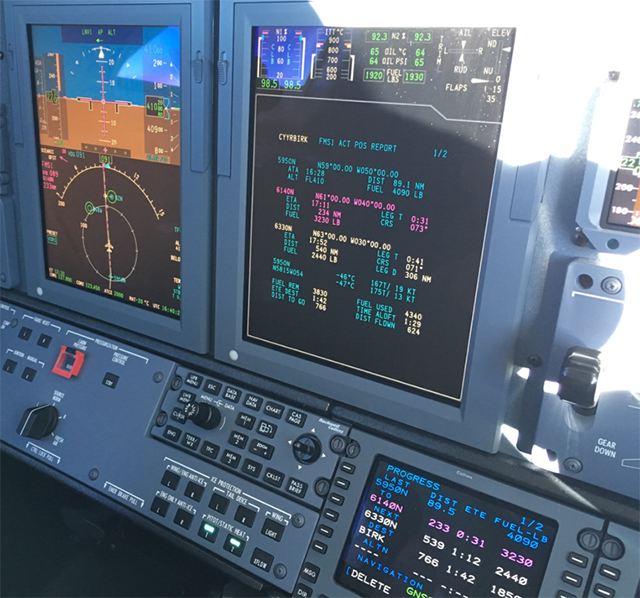
Photo: FMS ACT POS REPORT Page, Citation CJ4 during North Atlantic Crossing (CYYR-BIRK), from Jason Herman.
Remember to utilize Strategic Lateral Offset Procedures (SLOP) over the North Atlantic whenever out of radar coverage and to switch your transponder to Mode/A code 2000 after 30 minutes from coast out unless still in ATS Surveillance airspace. 10-minute post position plots should be a must to ensure you are on course and will remain on course. You may be able to utilize your iPad with GPS to confirm your position reference the assigned route as you proceed eastbound. Screen shots are an effective way to capture position, course, and altitude at each fix. Much of the technical information from the NAT 007 Document is contained on the text panels on the Jeppesen North Atlantic Orientation chart if you are looking for some light reading material or a brief refresher along the way.
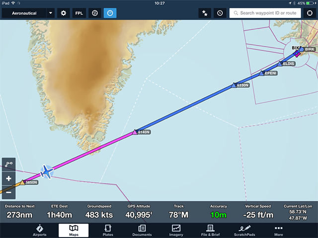
Photo: Screen shot from ForeFlight approximately 10 minutes past 58N/50W en route to BIRK at FL 410, from Jason Herman.
Coasting in to Keflavik or Reykjavik, there are required arrival fixes that operators are required to file and fly. Be sure to check the Jeppesen Airway Manual for Iceland to obtain this information which is extracted directly from the Icelandic AIP. For example, approaching from the west, aircraft are required to route over EPENI, direct ELDIS for BIRK. The previous single arrival fix of EMBLA is no longer used. Radar identification is usually completed by just after 30W and certainly before the first arrival fix.
The transition altitude in Iceland is around FL70 (listen to the BIRK or BIKF ATIS to obtain the Transition Level), so be sure to reset the transition altitude in your FMS to the appropriate value in addition to changing your barometric altimeter from Inches to Millibars.
For those tech stopping in Iceland and continuing on the Europe, Keflavik (BIKF) seems to be the preferred stop due to the long runways, good services, inexpensive fuel and handling, and ease of use. Those looking for a one or two day Icelandic adventure may want to consider Reykjavík (BIRK) as it is much closer to the city with a number of hotels and attractions nearby. The runways are considerably shorter at BIRK so a detailed runway analysis is prudent, especially if wet or icy contamination is expected. Both airports have excellent instrument approaches, ATC, and ground handling services given advanced notice, with Keflavik serving as a suitable alternate for arrivals into Reykjavik.
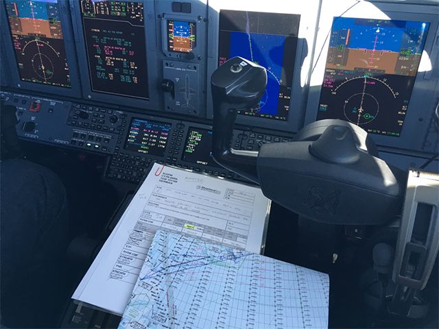
Photo: En route from Goose Bay to Reykjavik Iceland, just past the Southern tip of Greenland at FL 410, from Jason Herman.
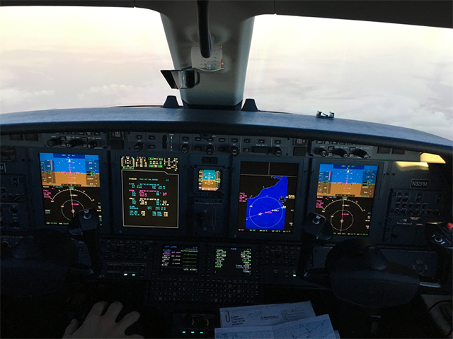
Photo: Approaching 63N/30W en route to Reykjavik, Iceland, from Jason Herman.
Departing Iceland for Europe
While the journey from Iceland to Europe is conducted in Oceanic airspace utilizing the same procedures as the flight from Canada to Iceland, ATS Surveillance airspace exists throughout the entire route of flight; therefore, no position reports are required. Departing Reykjavik, the Tower will switch you to Reykjavik Control (BIRD) for radar identification and climb. They will monitor your progress during the flight across the short 250 nautical mile oceanic segment however SLOP is permitted in this oceanic airspace. Just like the required arrival fixes, there are mandatory departure fixes/routes out of Iceland. The Jeppesen Airway Manual once again lays out all of these required routes. That being said, Reykjavik Control will likely offer a shortcut downstream once clear of any traffic.
For those aircraft not equipped with HF radio, Shanwick Oceanic CTA (EGGX) will not allow non-HF aircraft to enter their airspace; therefore, those aircraft will be required to route over RATSU intersection (61N/10W) which may add a few extra minutes to the flight plan, though not significant. Aircraft equipped with HF radio may enter the northeast corner of Shanwick CTA on their coast in to Scottish airspace.
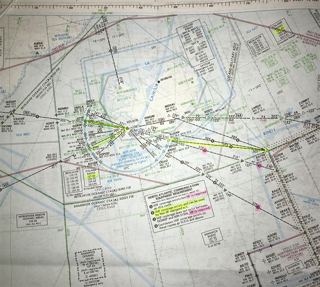
Photo: Blue Spruce Routes from Iceland to Europe (Note: RATSU intersection at 61N/10W), from Jason Herman
Pink highlighted routes require HF Radio through Shanwick CTA
With respect to Immigration, it is important to note that Iceland is part of the Schengen agreement, mitigating the need to clear immigration at most European countries except for UK, Ireland, Hungry, Bulgaria, and Romania. Ireland, Switzerland, and Norway happen to be three non-EU countries that are members of the Schengen agreement for immigration purposes. That being said, EU countries may permit temporary border controls even when traveling from Schengen countries so be sure to check where you are headed for specific requirements. It is also important to note that the EU Customs Area is separate from the Schengen immigration discussion.
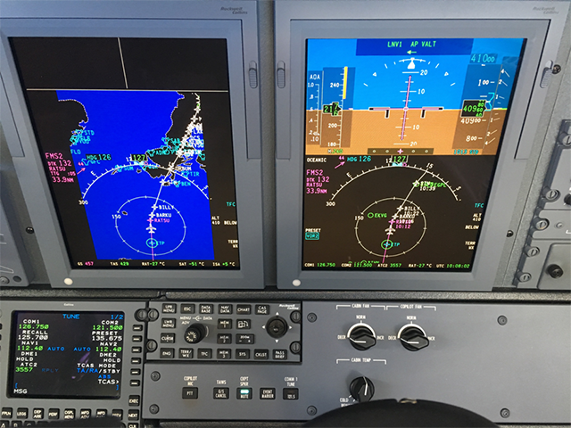
Photo: Approaching Coast-In at RATSU intersection, from Jason Herman.
Westbound Journey to Iceland
Reversing the route while traveling back to Iceland is similar to the eastbound trek with one significant exception. If departing from inland Europe, you will have to obtain your oceanic clearance from Iceland Radio prior to oceanic entry. This typically is accomplished about 25 minutes prior to entry fix while in Scottish airspace. VHF frequencies are available to ease the process and request/obtain your oceanic clearance. If assigned level/speed differs from your current level or speed, be sure to coordinate with Scottish Control to climb/descend or adjust speed prior to oceanic entry in accordance with the clearance. The VHF frequencies for Iceland Radio are referenced on the North Atlantic Orientation Chart in a text panel.
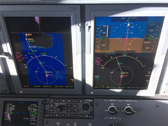
Photo: Approaching RATSU westbound at FL 450, en route to BIRK, from Jason Herman.
If you venture further north be advised that under 14 CFR 135 you may need OpSpec approval. Even under 14 CFR 91 there are a lot of other concerns, see High Latitude Operations.
— James
Departing Iceland for Canada
Much of the journey from Iceland to Canada is the same as the eastbound journey; however, if returning to the Western USA, it may be more favorable to fly great circle route on the way back to take advantage of the shorter distance and lesser headwinds.
If venturing back to the West Coast, a common route is from Iceland to Frobisher Bay Iqaluit/CYFB) in very Northern Canada. One of the challenges with this route is the lack of suitable alternates, particularly at the destination. FroBay is extremely isolated and often experiences rapidly changing weather conditions up at nearly 64 degrees North latitude. In fact, the closest suitable alternate with a paved runway (there are a few other aerodromes closer but they only have gravel runways) and approaches reference to magnetic north is nearly 340 nautical miles south of CYFB. That is a considerable distance if FroBay becomes unusable for any reason, so lots of extra gas is important here.
Anyone who has ever landed at FroBay with snow on the ground will tell you it is akin to landing on the moon. There is really not much there and cell phone coverage is nil to poor at best. Fortunately, Iqaluit radio (FSS) operates the Mandatory Frequency (MF) and will provide your outbound clearance and IFR clearance validation when ready to depart.

Photo: Over Central Greenland, en route to Frobisher Bay, Canada (CYFB), from Jason Herman.
An international trip like this is quite an undertaking, certainly more difficult than what we do in the Gulfstream world. Jason is to be congratulated for achieving this milestone. I am grateful he has volunteered to pass along his lessons learned.
— James
Putting It All Together
Flying a light jet across the pond does not have to be difficult, but does require intense focus and preparation. This article is not designed to be a complete and comprehensive guide to flying this mission, but does highlight many of the logistical requirements and operational considerations. One of the best resources for making this trip for the first time is reaching out to other pilots who have recently completed a similar journey. Additionally, NBAA maintains an International Feedback Database with info from operators on various airports around the world. If properly planned and executed, this journey can be one of the most enjoyable, exhilarating, and rewarding flights you will ever fly.
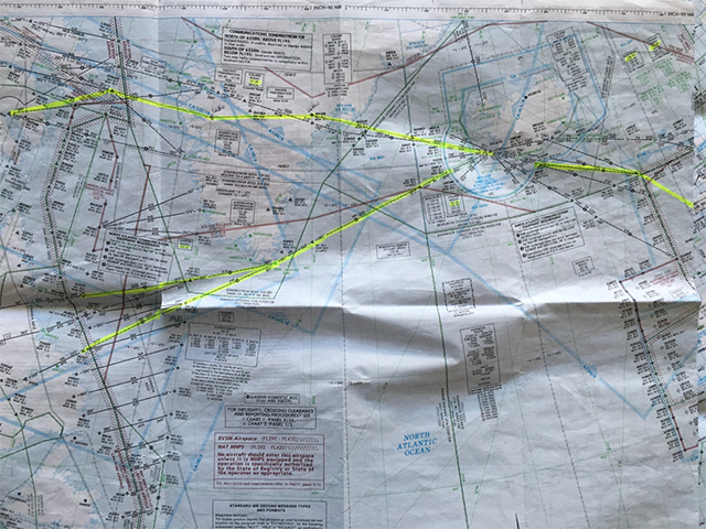
Photo: North Atlantic Orientation Chart, Blue Spruce Routes Highlighted, from Jason Herman.
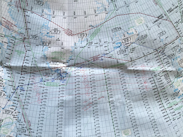
Photo: North Atlantic Plotting Chart from a recent Crossing in a light jet, from Jason Herman.

Photo: Sunset in Reykjavik, Iceland reflecting off of a Citation CJ4, from Jason Herman.