What is a circling approach? Does it require keeping the airplane precisely on the Minimum Descent Altitude within the published visibility distance or TERPS circling radii? If you think that is true, you are setting yourself up for unnecessary challenges at Teterboro.
— James Albright

Updated:
2018-01-15
Why is that? Well there are three issues with "circling" at Teterboro:
- NY / NJ / Philadelphia airport dynamics means no one airport's runway selection is determined in isolation.
- The FAA requires the "circle to runway 01" terminology even when what you are doing really isn't circling.
- Some pilots don't understand what it takes to fly a stable approach when visually maneuvering for landing.
If you are looking for hints on how to operate at Teterboro, give the Teterboro Airport page a look first. This page is dedicated to learning how to best handle a circling clearance from approach control or tower at Teterboro. I do have a suggestion for Teterboro procedure designers and operating techniques for pilots.
On May 15th, 2017, I was scheduled to fly into Teterboro with passengers who needed to be in Manhattan. KTEB was the closest viable airport. The winds were forecast 340/25G40 which meant the only option would be to fly the ILS to Runway 06 and then circle to Runway 01. The ceiling and visibility were fine, but when the winds are like that, you can't fly into Teterboro unless you fall into line. A straight in to Runway 01 is out of the question, you would get in Newark's way.
The magnetic heading for Runway 01 is 016° and that crosswind comes to 40sin(36) = 23.51 knots. The "demonstrated crosswind" on a Gulfstream 450 is 24 knots. So we can go, right? What if the wind direction changes or the velocity increases? We were due to leave later that evening and what if we were able to land but not takeoff?
There was one more factor to consider. That "circle" would be with an overshooting wind. Could we do that? I have flown that exact procedure with a 30 knot wind, but not 40. I elected to head for White Plains (KHPN) where Runway 34 was better aligned with the wind.
We as pilots have to make the "go" / "no go" decision knowing what the tower has planned for us. And when we decide to "go" we need to understand how to fly these procedures to put the odds in our favor. Fortunately you can do that with one thought in mind: a stabilized approach.
This isn't a creation of mine. See Emails, below, for one flight department's solution. Many pilots have come to the same conclusions and have been using these techniques for years. Many, but not all. On a windy day with circles to Runways 1 or 24, you will notice about half the pilots out there doing it all wrong. Let's change that.

1
NY / NJ / Philadelphia airport dynamics
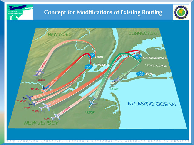
NY / NJ / Philadelphia airspace redesign, from faa.gov
There are times when the ILS 06 Circle 01 and the ILS 19 Circle 24 are required because the crosswinds on the ILS runway are just too high. But there are also times when the choice of Runway 01 and 24 for landing doesn't seem to make any sense but in fact is determined by the overall New York City airport situation. We are able to deal with it and the ILS 06 Circle 01 is perfectly usable. Until it isn't. But part of the problem is just what that term, "circle," means.
2
The FAA
The term "circling approach" means something very specific to most instrument rated pilots. We are evaluated at least once a year on our ability to keep the airplane very low (at the minimum descent altitude) and very slow (so as to maneuver within specified radii). Pilots, whether they know it or not, have an instinctual motivation to keep the airplane as close to the airport environment as possible. Can't lose sight! See: Circling Approach for more about this instinct. In the view of the FAA, however, the term is much broader.
- Circling approach instructions may only be given for aircraft landing at airports with operational control towers.
- Include in the approach clearance instructions to circle to the runway in use if landing will be made on a runway other than that aligned with the direction of instrument approach. When the direction of the circling maneuver in relation to the airport/runway is required, state the direction (eight cardinal compass points) and specify a left or right base/downwind leg as appropriate.
Source: FAA Order JO 7110.65V, ¶4-8-6.
CIRCLE TO RUNWAY (RUNWAY NUMBER)− Used by ATC to inform the pilot that he/she must circle to land because the runway in use is other than the runway aligned with the instrument approach procedure. When the direction of the circling maneuver in relation to the airport/runway is required, the controller will state the direction (eight cardinal compass points) and specify a left or right downwind or base leg as appropriate; e.g., “Cleared VOR Runway Three Six Approach circle to Runway Two Two,” or “Circle northwest of the airport for a right downwind to Runway Two Two.”
Source: FAA Order JO 7110.65V, Pilot/Controller Glossary
A "circling approach" can simply be a means of aligning the aircraft to an alternate runway. You don't even have to be on an instrument approach. You could, for example, be a VFR only pilot on visual approach to one runway and be cleared to circle to another. In this case, it has nothing to do with your instrument flight plan or rating.
This can lead to instrument pilot confusion. If you are on an IFR flight plan and you are instrument rated, clearance for a circling approach might be a clearance following your instrument approach, or it might just be a visual approach that follows an instrument approach. Whaaaah? What about a visual approach?
A visual approach is an ATC authorization for an aircraft on an IFR flight plan to proceed visually to the airport of intended landing; it is not an instrument approach procedure. Also, there is no missed approach segment. An aircraft unable to complete a visual approach must be handled as any go-around and appropriate separation must be provided.
Source: FAA Order JO 7110.65V, ¶7-4-1.
ARTCCs and approach controls may clear aircraft for visual approaches using the following procedures:
- Controllers may initiate, or pilots may request, a visual approach even when an aircraft is being vectored for an instrument approach and the pilot subsequently reports:
- The airport or the runway in sight at airports with operating control towers.
- The airport in sight at airports without a control tower.
- Resolve potential conflicts with all other aircraft, advise an overtaking aircraft of the distance to the preceding aircraft and speed difference, and ensure that weather conditions at the airport are VFR or that the pilot has been informed that weather is not available for the destination airport. Upon pilot request, advise the pilot of the frequency to receive weather information where AWOS/ASOS is available.
NOTE− Towers may exercise this authority when authorized by a LOA with the facility that provides the IFR service, or by a facility directive at collocated facilities.
PHRASEOLOGY - (Call sign) (control instructions as required) CLEARED VISUAL APPROACH RUNWAY (number);
Source: FAA Order JO 7110.65V, ¶7-4-3.
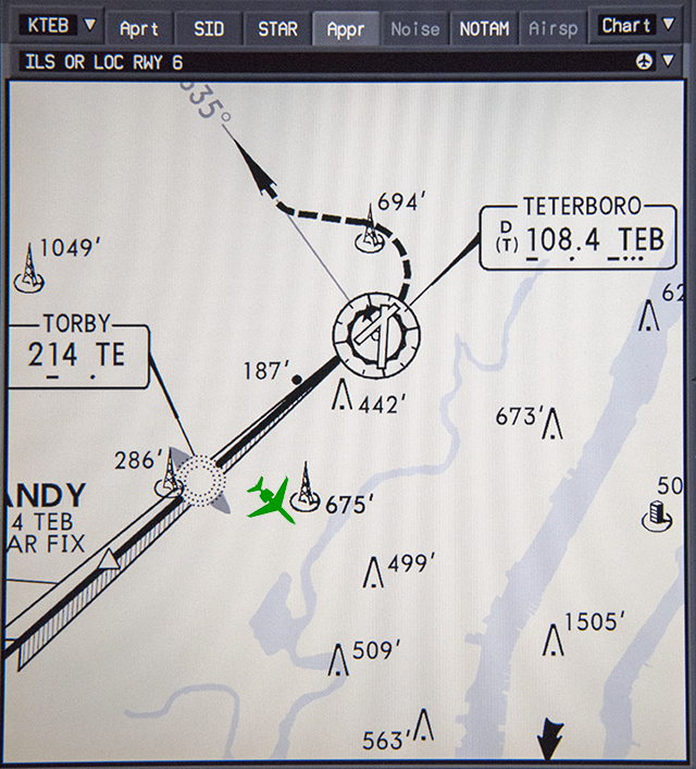
While the controllers do not always use the exact same terminology and sometimes the word "circle" does slip into the clearance, more often than not you will be told "After TORBY enter left base to Runway One." "I've also heard, "Cleared the ILS zero six, circle to zero one," and "after TORBY circle zero one." But even if the term "circle" isn't used, we almost always hear "circle to Runway One." It's what we expect to hear and what our brain deciphers the instruction to be. But the controller doesn't mean he wants you to glue the airplane to within your category circling radii or visibility minimums. Don't believe me? Let's look at the Teterboro ILS 06 approach plate minima section:
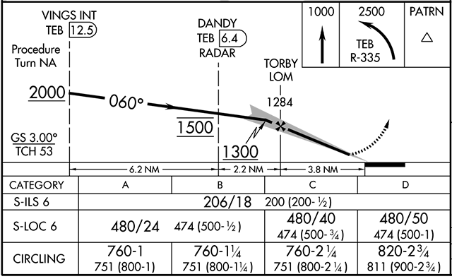
Teterboro ILS or Localizer Runway 6 Minima, from FAA Approach Plate KTEB, 27 April 2017
Circling approach radii have changed. Under the old rules a Category C aircraft had to remain within 1.7 nm of the airport. Under newer rules, the radii depends on other factors but in general, for a sea level airport, tends to be around 2.7 nm. More about this: U.S. Circling Approach Minimums Are Too Low. Further, the visibility minimums for a Category C aircraft of this approach is 2.25 sm, which comes to only 2.17 nm. So, depending on which number you like, if you were shooting the Teterboro ILS Runway 06, Circle to Land Runway 01 on a check ride, you would be expected to keep the airplane within 1.7, 2.17, or 2.7 nautical miles. So what?
Give this video a look: KTEB ILS 06 Circle 01. I shot this approach a few years back. I began the circle at TORBY; that's 3.8 nm from the airport! Every now and then I got that specific instruction, but more often than not I just did it. There is a debate among many Teterboro veterans about this, more about that below.
So your clearance to "circle" doesn't require you to "circle" so much as to "visually maneuver." But approach control and tower are somehow constrained to use the terminology and we pilots somehow feel pressure to keep the airplane in tight. I've been starting the circle at TORBY for ten years now and have never gotten any push back from anyone. But there are times when the winds are so strong any kind of visual maneuver is just not possible.
3
Some pilots don't understand stable approach dynamics
It isn't the crosswind landing that is particularly dangerous at Teterboro however, it is the crosswind during the circling maneuver to get from the approach path of one runway to the next that can be particularly challenging. When the winds make landing on Runway 06 too risky, the same wind can make the final turn onto Runway 01 even more so. The same can be said for the approach to Runway 19 followed by a circle to Runway 24. Why? It is because many pilots throw out the concept of a stable approach as soon as they hear the term, "circle to runway . . ."
The Longitudinal Component of a Stable Approach
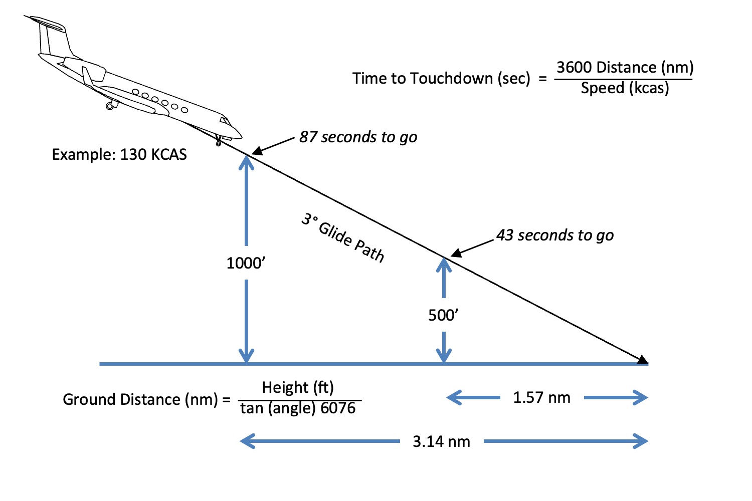
Time to touchdown
Just about everyone these days preaches the need for a stable approach and just about everyone defines a stable approach as being on speed, on glide path, on centerline no later than 500 feet above the runway. Also specified in many manuals is that you must be in this position configured and in a landing attitude. (If you are on the extended centerline at 60° of bank you aren't stable.) But what is lost on many people is that doing this off a 3° glide path takes distance, 1.57 nm to be exact.
For more about this, see: Stabilized Approach.
ILS Runway 06 - Circle to Runway 01
Let's look at a series of "circling" approaches coming off the ILS Runway 06 followed by a right turn to base and ending with a left turn onto final for Runway 01. We'll do this for a no wind situation as well as a wind of 340/16G30. In my aircraft that wind requires a 20 knot additive, using half the steady wind plus the full gust increment, but no less than 5 or greater than 20. (1/2 of 16 plus 14) With a typical VREF of 130, that means I will be flying at 150 knots.
A rule of thumb for determining your turn radius at low altitudes and 25° of bank is to divide your speed (in nautical miles per minute) by 3. Flying at 150 knots (2.5 nm/min) gives you a turn radius of 0.83 nm. For more about how to find this, see: Turn Performance. Armed with this knowledge, we can plot our flight path.
So we are left with the decision on where to aim when setting up our base to Runway 01:

"Aim Decision"
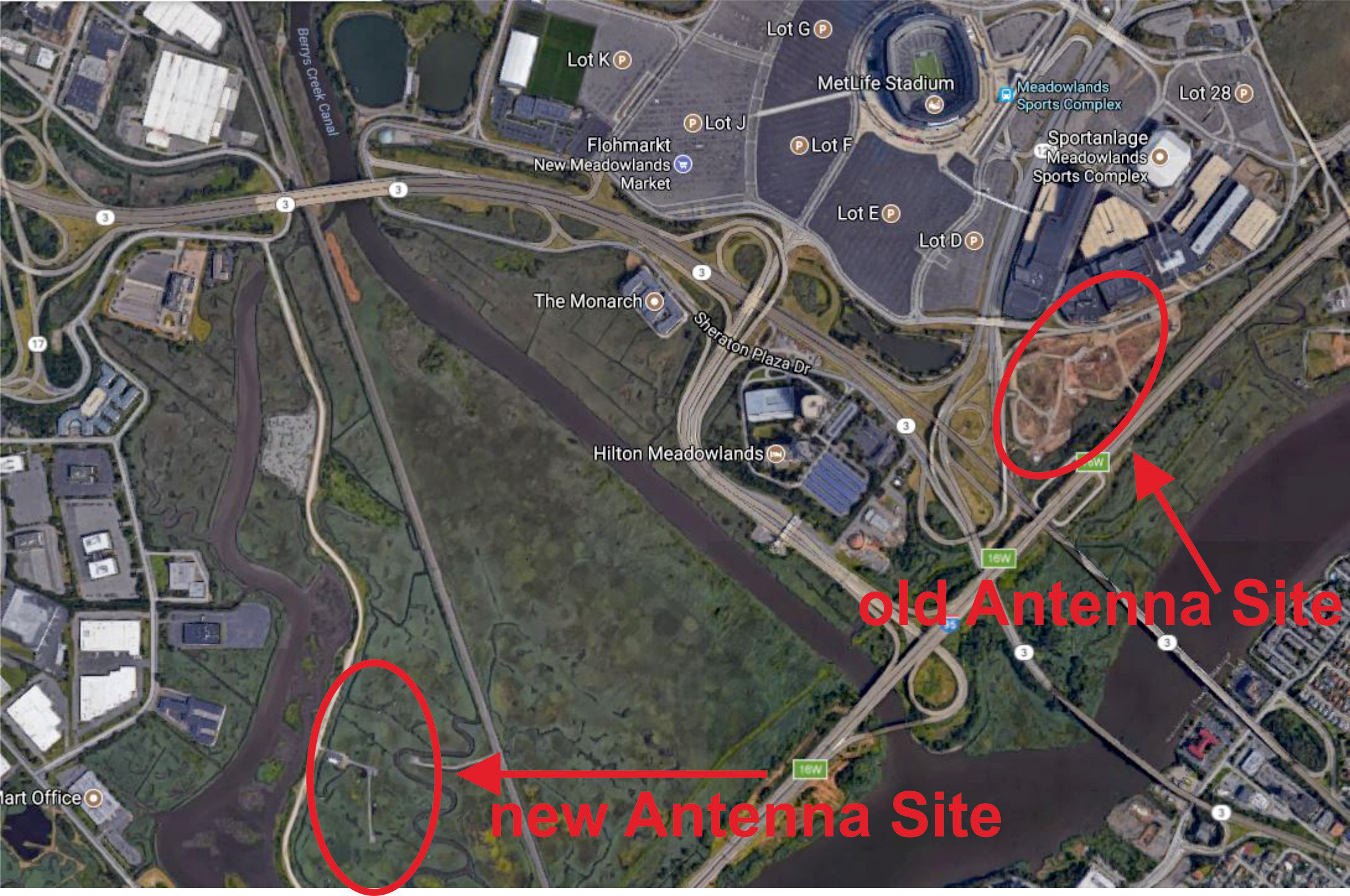
Note: The radio towers have since moved, see Emails, below.
Update:

An updated view, 2018
The radio towers have been moved out of the way so now you are just looking at the stadium and Xanadu. I've started to fly this by flying the localizer, not descending on the glide slope, and holding 1,300' TORBY altitude on base, and only begining the descent once needed to make a nice 3° glide path for Runway 01. This shot taken on base at 1,300'. You can see Runway 01 in the distance.
The ILS 06 - Circle to 01 makes for a good test to see if a pilot really understands (or believes) in stable approaches. I've met many pilots who claim you need to turn from the ILS 06 to a base to Runway 01 by aiming inside one of three landmarks: the stadium ("MetLife" or "Giant" stadium, depending on your age), Xanadu (also known as American Dream Meadowlands), or the radio towers just outside. To some pilots, a turn outside these landmarks shows you are of "lesser stock."
Some pilots may argue that you need to turn inside the stadium because there is a TFR that forbids flying over it. As of this writing the most recent version of that nationwide TFR is 4/3621 which reads, in part:
SPECIAL SECURITY NOTICE SPORTING EVENTS . . . . THE FEDERAL AVIATION ADMINISTRATION (FAA) CLASSIFIES THE AIRSPACE DEFINED IN THIS NOTAM AS 'NATIONAL DEFENSE AIRSPACE'. ANY PERSON WHO KNOWINGLY OR WILLFULLY VIOLATES THE RULES PERTAINING TO OPERATIONS IN THIS AIRSPACE MAY BE SUBJECT TO CERTAIN CRIMINAL PENALTIES UNDER 49 USC 46307. PILOTS WHO DO NOT ADHERE TO THE FOLLOWING PROCEDURES MAY BE INTERCEPTED, DETAINED AND INTERVIEWED BY LAW ENFORCEMENT/SECURITY PERSONNEL. PURSUANT TO 14 CFR SECTION 99.7, SPECIAL SECURITY INSTRUCTIONS, COMMENCING ONE HOUR BEFORE THE SCHEDULED TIME OF THE EVENT UNTIL ONE HOUR AFTER THE END OF THE EVENT. ALL AIRCRAFT OPERATIONS; INCLUDING PARACHUTE JUMPING, UNMANNED AIRCRAFT AND REMOTE CONTROLLED AIRCRAFT, ARE PROHIBITED WITHIN A 3NMR UP TO AND INCLUDING 3000FT AGL OF ANY STADIUM HAVING A SEATING CAPACITY OF 30,000 OR MORE PEOPLE WHERE EITHER A REGULAR OR POST SEASON MAJOR LEAGUE BASEBALL, NATIONAL FOOTBALL LEAGUE, OR NCAA DIVISION ONE FOOTBALL GAME IS OCCURRING. THIS NOTAM ALSO APPLIES TO NASCAR SPRINT CUP, INDY CAR, AND CHAMP SERIES RACES EXCLUDING QUALIFYING AND PRE-RACE EVENTS. FLIGHTS CONDUCTED FOR OPERATIONAL PURPOSES OF ANY EVENT, STADIUM OR VENUE AND BROADCAST COVERAGE FOR THE BROADCAST RIGHTS HOLDER ARE AUTHORIZED WITH AN APPROVED AIRSPACE WAIVER. AN FAA AIRSPACE WAIVER DOES NOT RELIEVE OPERATORS FROM OBTAINING ALL OTHER NECESSARY AUTHORIZATIONS AND COMPLYING WITH ALL APPLICABLE FEDERAL AVIATION REGULATIONS. THE RESTRICTIONS DESCRIBED ABOVE DO NOT APPLY TO THOSE AIRCRAFT AUTHORIZED BY AND IN CONTACT WITH ATC FOR OPERATIONAL OR SAFETY OF FLIGHT PURPOSES . . .
A 3NM circle drawn around the center of MetLife Stadium includes every paved surface at Teterboro Airport, but as long as you are talking to tower you are okay. So don't think flying inside the stadium is legally necessary. Besides, even on a calm wind day, turning inside the stadium makes a stable approach impossible:

Teterboro ILS Runway 06 Circle to Runway 01, unstable approach, no wind, from GoogleEarth with my notes.
If you limit yourself to 25° bank (as you should) turning inside of the stadium will cause you to rollout on final for Runway 01 just 0.75 nm from touchdown at an altitude of 250' above the runway. That's half your professed stable approach height!
Starting the turn so as to maneuver just outside of the stadium, Xanadu, and towers, you roll out exactly where you need to be for a stable approach, 1.57 nm from touchdown at 500 feet above the runway:
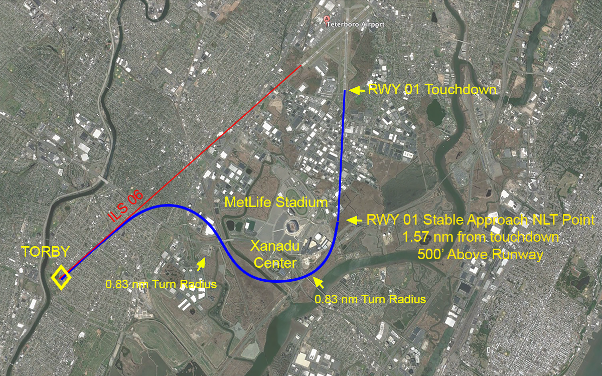
Teterboro ILS Runway 06 Circle to Runway 01, stable approach, no wind, from GoogleEarth with my notes.
And we didn't have to begin our turn until a mile or so after TORBY.
Now what happens if we throw in our 20 knot wind from the northwest? Our turn radius will be greatest with the wind at our back and that requires we begin our turn at TORBY:
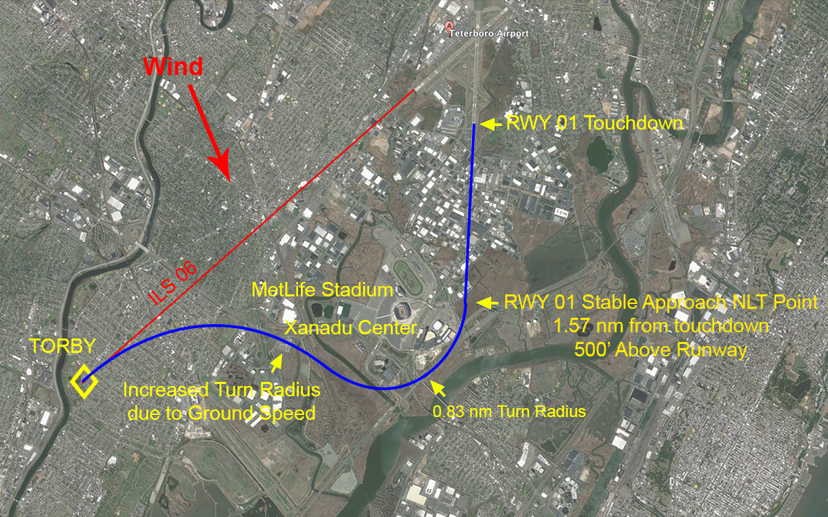
Teterboro ILS Runway 06 Circle to Runway 01, stable approach, 20 knot crosswind, from GoogleEarth with my notes.
But even with that wind, starting our turn earlier allows us to avoid overflying the stadium, Xanadu, and the towers and still roll out on final for a stable approach. Now what if we still insist on flying inside the stadium?

Teterboro ILS Runway 06 Circle to Runway 01, unstable approach, 20 knot crosswind, from GoogleEarth with my notes.
Well it simply cannot be done. We will need to increase our bank angle but even then we are likely to end up over the stadium and then it will be impossible to rollout on course. Limiting the bank angle to 45° I think you might be able to roll out over the numbers at 80 feet. That is hardly a stable approach!
ILS Runway 19 - Circle to Runway 24
The ILS Runway 19, Circle 24 is easier in two respects but harder in two others. It is easier because you don't have to worry about encroaching onto Newark's airspace and you don't have to worry about overflying the MetLife Stadium, the Xanadu Center, or those radio towers. But it is harder because you don't have any good visual references and things happen much faster due to the proximity of both runway ends. Depending on your avionics, there are techniques to help.
You are normally given clearance for the ILS Runway 19, circle to Runway 24, with a speed restriction until TUGGZ. TUGGZ is 4.5 nm from the end of Runway 19. The point at which time to start your maneuvering is hard to judge because the end of each runway is very near and the angle between them quite small. Generally speaking, for an airplane flying at 150 knots, turning 3 miles from the end of Runway 19 works with no winds. How do I know that?
- I want to be rolled out no later than 1.57 nm from touchdown.
- The normal touchdown point is 1,000 ft (0.16 nm) down the runway.
- Let's subtract 0.16 from the 1.57 and say we want to roll out 1.57 - .16 = 1.41 nm from the end of the runway.
- Our two turns make up an "S-turn" and almost amount to two turn radii added, so that's 0.83 + 0.83 = 1.66 nm
- So 1.41 + 1.66 = 3.07, which is close enough to 3 to call it 3 nm. Drawing it to scale validates this:
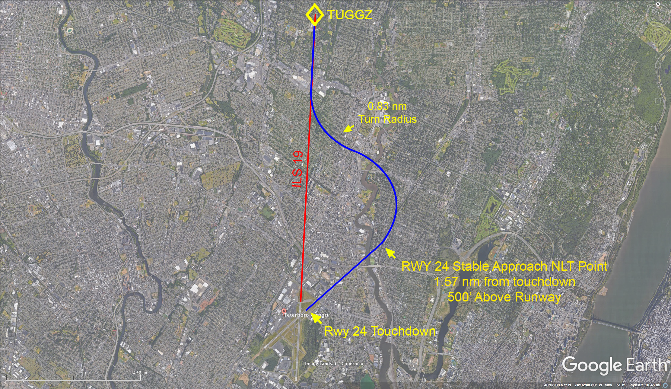
Teterboro ILS Runway 19 Circle to Runway 24, stable approach, no wind, from GoogleEarth with my notes.
What about a 20 knot overshooting wind? You can compute that by understanding the entire airmass is moving 20 knots to the east. Knowing that it takes (d/v) = (4.5 nm) / (150 nm / hr) = 0.03 hours to fly from TUGGZ to the end of Runway 19, we can approximate our eastward lateral drift during that time to be vt = (20 nm/hr) (0.03 hr) = 0.6 nm. Graphically:

Teterboro ILS Runway 19 Circle to Runway 24, stable approach, 20 knot overshooting wind, from GoogleEarth with my notes.
WARNING: When in this very situation tower is inclined to ask you to "square your turn" because the airplane in front of you overshot and will take longer than expected to line up and land. This of course may cause you to overshoot and do the same. (I've fallen for this once.) Here is where turning at TUGGZ to establish the longest possible final will come in handy.
We see that starting the initial turn a half mile early seems to give us an extra half mile to line up on Runway 24 in time to make a stable approach. Easy? Well knowing where to aim for roll out is the issue here. How about a better way?
4
Suggestion For Teterboro procedure designers
If ever there was need for a charted visual flight procedure, the ILS Runway 06, circle to Runway 01 is it. That would put everyone on a predictable flight path and eliminate the temptation to fly too tight.
- CVFPs are charted visual approaches established for environmental/noise considerations, and/or when necessary for the safety and efficiency of air traffic operations. The approach charts depict prominent landmarks, courses, and recommended altitudes to specific runways. CVFPs are designed to be used primarily for turbojet aircraft.
- These procedures will be used only at airports with an operating control tower.
- Most approach charts will depict some NAVAID information which is for supplemental navigational guidance only.
- Unless indicating a Class B airspace floor, all depicted altitudes are for noise abatement purposes and are recommended only. Pilots are not prohibited from flying other than recommended altitudes if operational requirements dictate.
- When landmarks used for navigation are not visible at night, the approach will be annotated “PROCEDURE NOT AUTHORIZED AT NIGHT.”
- CVFPs usually begin within 20 flying miles from the airport.
- Published weather minimums for CVFPs are based on minimum vectoring altitudes rather than the recommended altitudes depicted on charts.
- CVFPs are not instrument approaches and do not have missed approach segments.
- ATC will not issue clearances for CVFPs when the weather is less than the published minimum.
- ATC will clear aircraft for a CVFP after the pilot reports siting a charted landmark or a preceding aircraft. If instructed to follow a preceding aircraft, pilots are responsible for maintaining a safe approach interval and wake turbulence separation.
- Pilots should advise ATC if at any point they are unable to continue an approach or lose sight of a preceding aircraft. Missed approaches will be handled as a go−around.
Source: AIM, §5-4-24.
5
Operating techniques
The best way to improve your "circling" at Teterboro (or anywhere else) is to understand you want to roll out 500' above the landing surface about a mile and a half from touchdown. The best way to do that is to increase your situational awareness by any means possible. As with many things in aviation, the more toys you have in the cockpit the easier it becomes, but all you really need is an approach plate. So here we go, from simplest to easiest, four techniques.
- Draw an extended centerline on the approach plate — Most approach plates will have some sort of scale on the side and you can measure 1-1/2 miles and draw a line on the extended final of your landing runway. From there imagine the turn radius and you will have an idea of when your turn needs to be made. Keep in mind that many real world circling approaches cannot be made to a stable final approach to keep within the posted visibility minimums. That might be your best clue that you don't want to circle at minimums. More about this: U.S. Circling Approach Minimums Are Too Low.
- Draw an extended centerline using the FMS — Some avionics suites will allow you to extend the runway centerline with a number of FMS keystrokes. If you size the display so as to have a meaningful range mark, you can shoot for the appropriate final. If, for example, you have a three mile range ring, you shoot for half that distance from touchdown.
- Size the display of a moving map with aircraft symbol so as to provide a visual base turn depiction — In our KTEB ILS 06 Circle 01 example, we can zoom into the approach plate and realize the distance between TORBY and Runway 06 is 3.8 nm. We should be shooting to roll out on final for Runway 01 at least half that distance from touchdown.
- Use Synthetic Vision — Some synthetic vision setups provide range marks from the landing runways, in which case you need only shoot for a point that allows you to roll out at least between the 1 and 2 nautical mile marks.
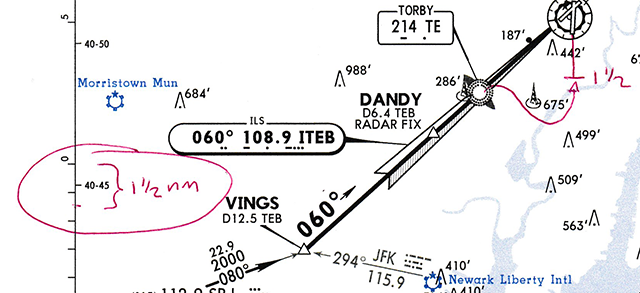
Handdrawn circle on approach plate.
In this example knowing where we must roll out and that our turn radius is approximately 3/4 nm tells us that we need to begin our circle soon after TORBY.
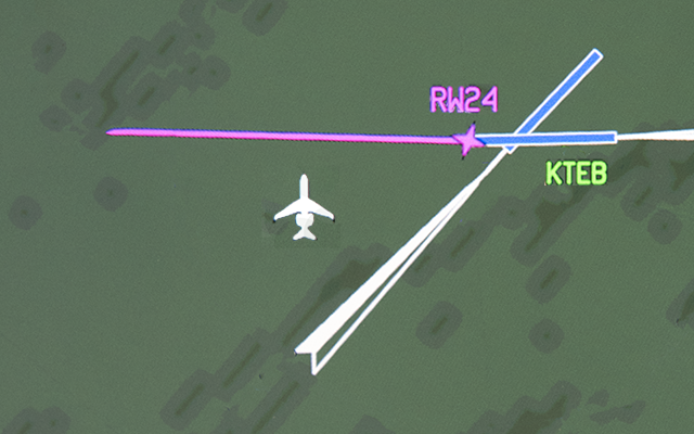
G450 DU map display, circle from ILS 19 to Rwy 24
If the runway is drawn to scale, you can use it to visualize a rollout point. In the example shown above, the runway is 1 mile long so you want to aim a runway and a half away. On other aircraft, the ILS "Feather" has a fixed scale and can also be used to judge distance.
Aircraft real time position shown on G450 display during visual maneuvering to Runway 01
Some simulator instructors will call this cheating. In the box that might be the case. But in real life this is called using all the tools available to keep things safe.
Synthetic vision display during visual maneuvering at KBED
You may need to change the landing runway from the one used for approach to the one used for landing. The Pilot Monitoring must know how to do this quickly and as early as possible to be able to remain "heads up" as the aircraft is maneuvering.
6
A few final thoughts
A reader brings up an excellent point about the unusual circumstance of really having to circle at minimums versus the visual maneuvering we are asked to do routinely. If Teterboro was at circling minimums and you had a large overshooting wind from the west, you would be wise to overfly the airport and set up for a right base into the wind as opposed to the standard procedure used on a VFR day. And if tower can't accommodate that, you filed an alternate, didn't you?
The VASI on Runway 01 are angled at 3.46° and that does change the distance from your stable approach height of 500 feet. It actually makes it shorter: 1.36 nm instead of 1.57 nm. I used the 3.00° angle and 1.57 nm because that is what you need at most airports and it is conservative for Teterboro. Besides, 0.21 nautical miles happens fast.
7
Emails
James,
BMW Flight Service is the car manufacturer's flight department operating 4 to 6 times a year into TEB, mostly with G550s. Most of our crews have experienced the famous “ILS 6 circle to 1” clearance for an approach, that is everything but a circle. Not just after the unfortunate crash of that Lear 35 last May we had this topic on the agenda in numerous pilots meetings. We've started a review of our own procedures on how to set things up safely and of course came across your thoughts and material published on the "code7700.com" website. While studying it and trying to find a safe flightpath and procedure we may have found something worth looking at even though I don't know if you're already aware of.
The Antenna site, which used to be just south of XANADO according to our investigation has been moved to a property approximately half a mile southwest somewhere around the year 2015. Looking into Google maps and positioning the "streetview-man" in HWY96W near the XANADO, looking west still shows the 3 antennas. This picture is from 2013. If you position the "streetview-man" on the little street circling around the XANADO just south of it an look onto the same property, the antennas are gone. This picture is from 2015.
Also, I was just returning from Recurrent Training at FSI and were taking HWY3 from the training center to our hotel and I remember the antennas south of HWY 3. See attached picture.
This does not sound like much, but fellow crews may find it irritating to look for antennas as displayed in the nice video and the track-graphics and find it in a very different place.
Attached also find a draft of our proposed procedure, which is similar to what you´ve prescribed and I'd be happy if you let me know your thoughts.
Best regards
Paul
The radio towers have moved (From Paul Stoeber)
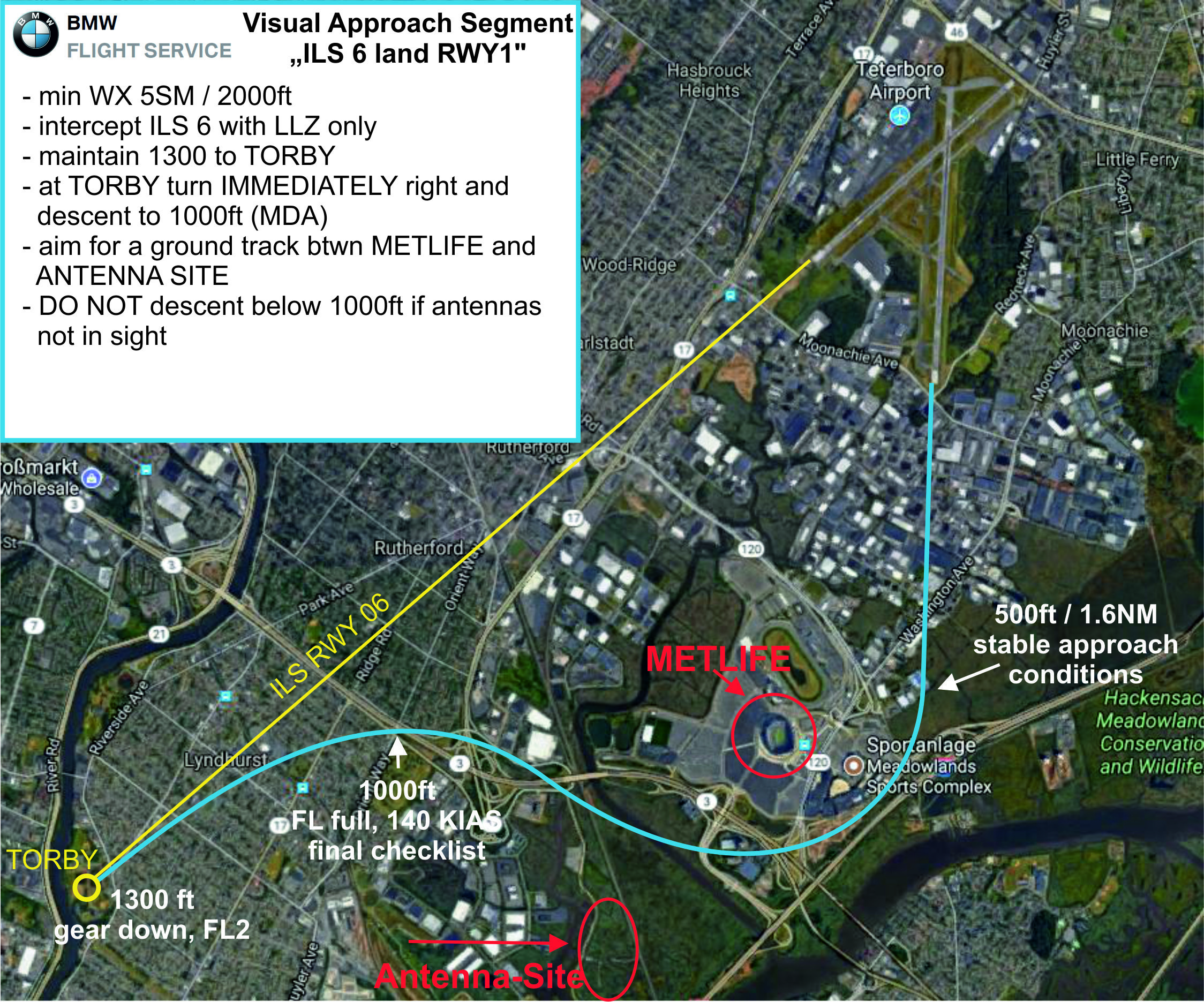
BMW Flight Service Circling Groundtrack (Paul Stoeber)
References
(Source material)
Aeronautical Information Manual
FAA Order JO 7110.65V, Air Traffic Control, April 3, 2014, Department of Transportation