When we pilots talk about metric altimetry, there are a two things to consider when it comes to dialing in the altimeter setting into what is properly called the Kollsman Window. First, are we setting it so the altimeter will end up reading our height above mean sea level when we are on the ground (QNH) or so it reads zero (QFE)? Second, what altimeter setting are we given, inches, hectopascals, millibars, or millimeters? The answers to these questions can mean the difference between leveling off at the proper altitude or missing that and flying into the ground. But only a portion of this discussion has anything to do with metric altimetry. I cover all of that here: Altimeter Settings.
— James Albright

Updated:
2020-12-27
There is another aspect of metric altimetry which is equally important: will you be flying your altitudes and heights in feet or meters?
The ICAO reference documents are remarkably silent on the subject of metric and QFE versus QNH altimeter operations, other than to say they are possible. Even the document devoted to summarizing differences, ICAO Doc 7030, fails to cover either subject. We are left to explore both subjects with hard-earned experience.
Things are getting easier because they are becoming more standard. As of late 2020, 188 out of 193 ICAO member states are using feet and QNH. The only countries still working in meters are China, Mongolia, North Korea, Russia, and Tajikistan. And those last two are only using metric in lower airspace. In Russia you will now get QNH below transition level unless you are a Russian aircraft, which can get mm Hg on request. I think all of those countries except Tajikistan are using QNH at most, if not all, airports.
So let's learn how to identify which systems your airport is using, and the best way to learn is to start with the ICAO standard.

1
Chart identification
I will be using Jeppesen approach charts as examples. If you are using charts from another provider, you will have some research to do.
Inches / hectopascals / millibars / millimeters
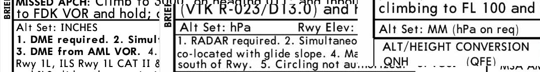
A comparison of inches, hPa, and mm
Looking just below the "Briefing Strip" and the left you should see "Alt Set:" and the method employed.
- "Inches" means you will be setting "inches of mercury," such as 29.92 in.
- "hPa" means you will be setting hectopascals, such as 1013. A hectopascal is equal to millibars.
- "mm" means you will be setting "millimeters of mercury," such as 720 mm.
For more about this, see: Altimetry Settings.
QFE / QNH
A comparison of QFE and QNH
There may be conversion tables on the chart to go from QNH to QFE and back, but the only way to be sure the chart is meant for QFE operations is to look at the minimums section and see which appears in bold.
- The altitude outside the parenthesis is bolded means the minimums are in relation to mean sea level and QNH is in use.
- The altitude inside the parentheses is bolded means the minimums are in relation to the runway and QFE is in use.
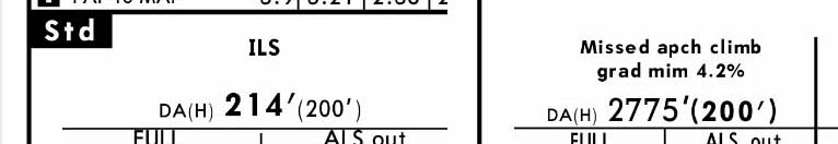
Feet / meters
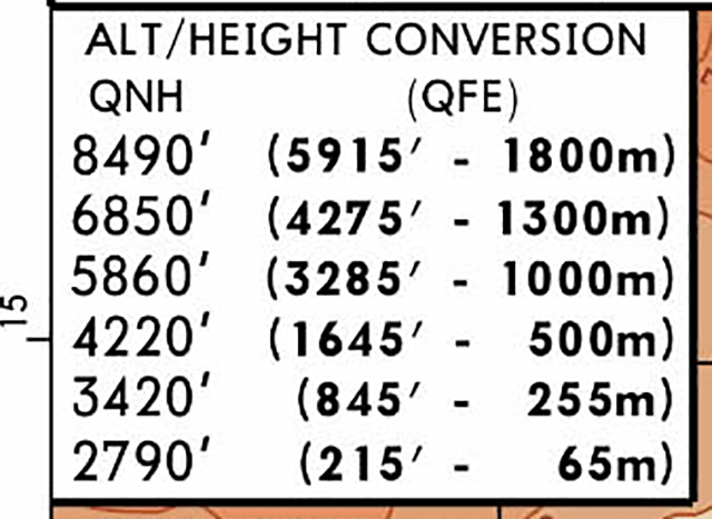
An example of a feet / meters conversion table
These approach charts do not give you a sure way to determine if the airport will be issuing altitudes in meters or feet, but there is one clue. The presence of a feet - meters tables indicates that they might be using meters. As of late 2020, only some airports in China, Mongolia, North Korea, Russia, and Tajikistan are using meters. But, importantly, not all the airports in these countries are using meters. The presence of a feet - meters table might be a convenience for those who are equipped for meters but the airport is using feet. If you are flying into these countries, it may be wise to use add "feet" or "meters" to your altitude reports on the radio.
Note: most countries outside the United States express visibility in meters, even thought they use feet for altitudes and heights.
2
ICAO procedures
The ICAO Standard
- Millimeters vs. Hectopascals: hPa
- QFE vs. QNH: QNH
- Metric vs. Feet: Feet
Example ILS DME Rwy 02C, WSSS
The example chart is almost identical to one that may be seen in the U.S. The two key differences are that the altimeter is set using hPa and the visibility minimums are expressed in meters.
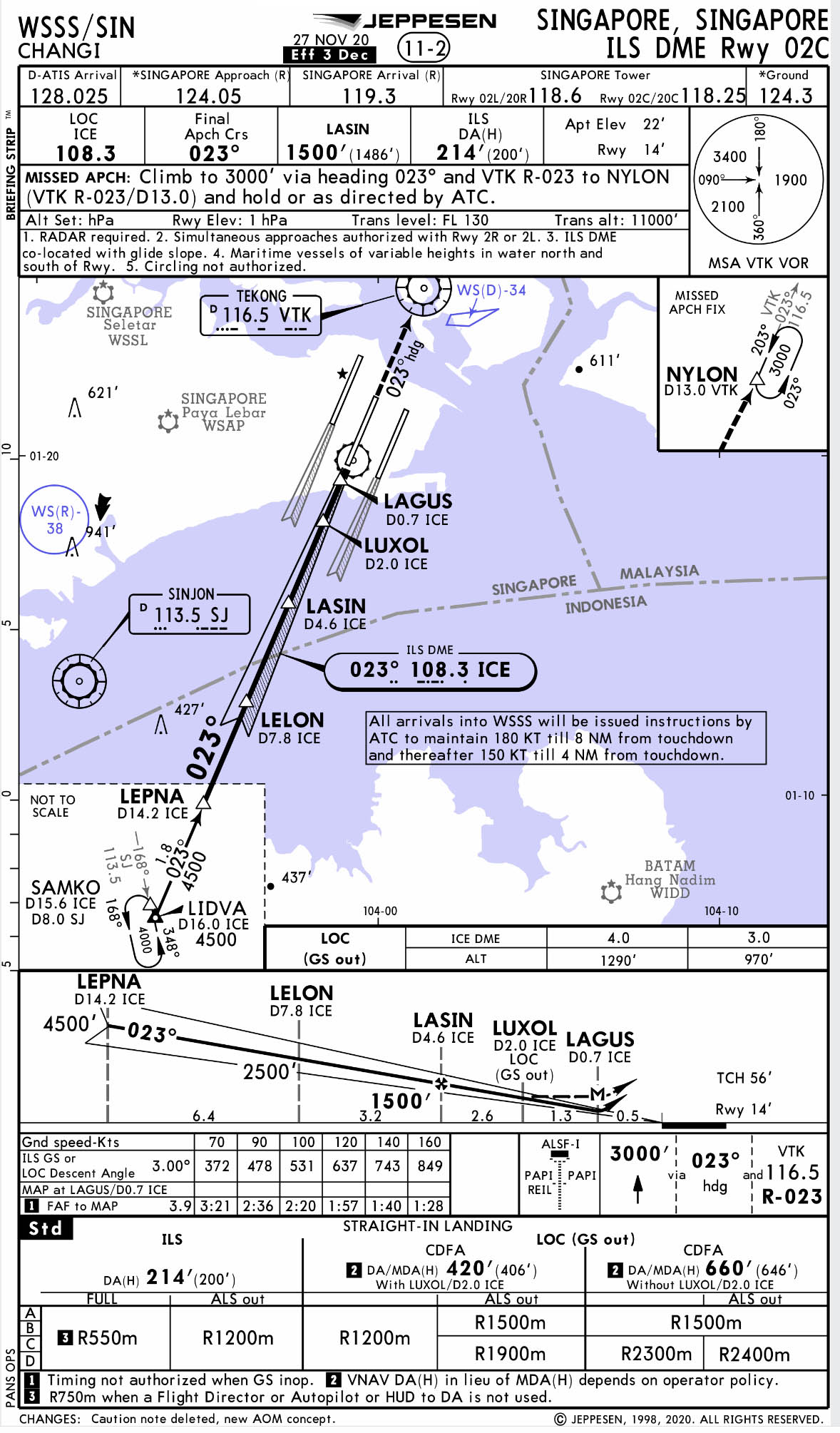
Example ICAO Standard Approach Chart, from Jeppesen
Singapore ILS DME Rwy 02C, WSSS, page 11-2, 27 Nov 20
3
QFE / metric procedures
QFE / Metric
- Millimeters vs. Hectopascals: mm
- QFE vs. QNH: QFE
- Metric vs. Feet: Meters
Example ILS DME Rwy 09, UTDD
The example chart shows the DA(H) as 2775'(200') with the 200 bolded, telling us this is a QFE airport. We suspect they are using meters instead of feet because there is a conversion table given. This is true for this airport and the controller should give altitudes in meters. You can expect, for example, to be vectored to the TOVGO final approach fix at "one thousand meters." If your avionics can do the conversion for you, you would set 1,000 meters. Otherwise, you would have to look at the table and set 3,285 feet instead.
For an example of a chart with a table not using QFE or Metric altitudes, see: Matryoshka.
If you, like me, spend most of your time climb and descending to altitude given in feet, flying in a metric environment should cause you to be hyper sensitive to all cleared altitudes. I flew twice into the main Beijing airport where the clearance was to descend and maintain "six hundred" and the other pilot dialed in 600 feet. That would have put us 1,400 feet below our assigned altitude and flying between buildings in a busy Chinese city. (Thankfully, Beijing gave up meters a few years ago.)
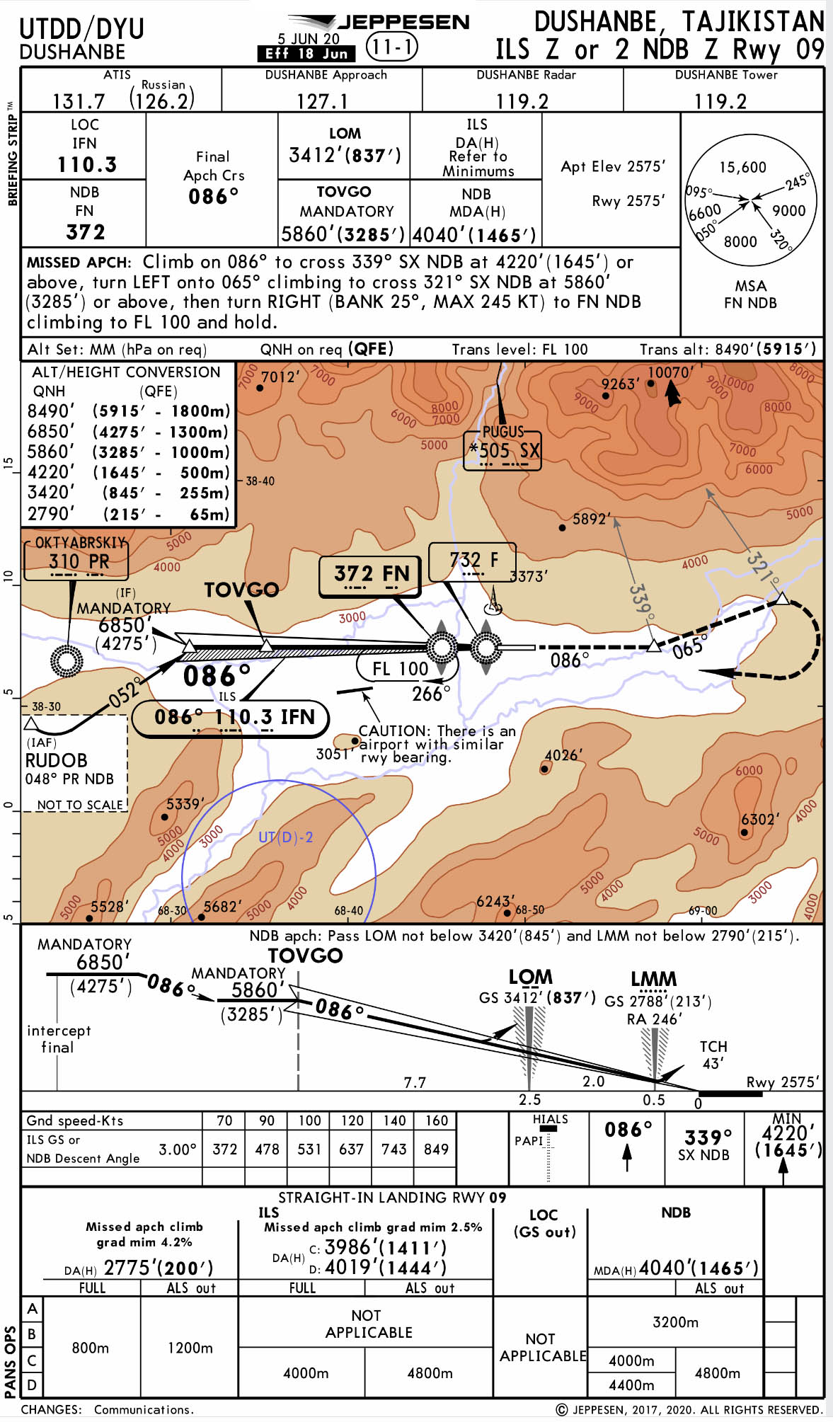
Example QFE / Metric Approach Chart, from Jeppesen Airway Manual,
Dushanbe, Tajikistan, ILS Z Rwy 09
4
Matryoshka
What is a "matryoshka," you ask? It is a Russian nesting doll, something hiding inside another thing. We ended up with a lot of "matryoshka charts" because formerly QFE/Metric countries are now using QNH/Feet but they have aircraft and pilots still using the older system. So these many airports in these countries continue to publish conversion tables as a convenience.
- Millimeters vs. Hectopascals: hPa
- QFE vs. QNH: QNH
- Metric vs. Feet: Feet
Example ILS Rwy 06L, UUEE
It is easy enough to see they will be giving you hPa altimeter settings because it says so right on the chart. You can see that they are using QNH because the DA is bolded, not the (H). This airport also uses feet for altitude but continues to publish the conversion chart. We can surmise they are using feet since those altitudes are given in fairly even numbers and the meters appear to be the conversions. (Notice it is just the opposite for the metric UTDD chart shown above.)
I would exercise a great deal of caution and make a point of adding "feet" to every altitude I say on the radio. If the controller says "Descend and maintain three thousand, clear the ILS Runway zero six left approach," I would read back, "Descend and maintain three thousand feet, clear the ILS Runway zero six left approach," just to be sure. The controller might get peeved but you never know when that controller has had a long day and might be reverting to the way things used to be.
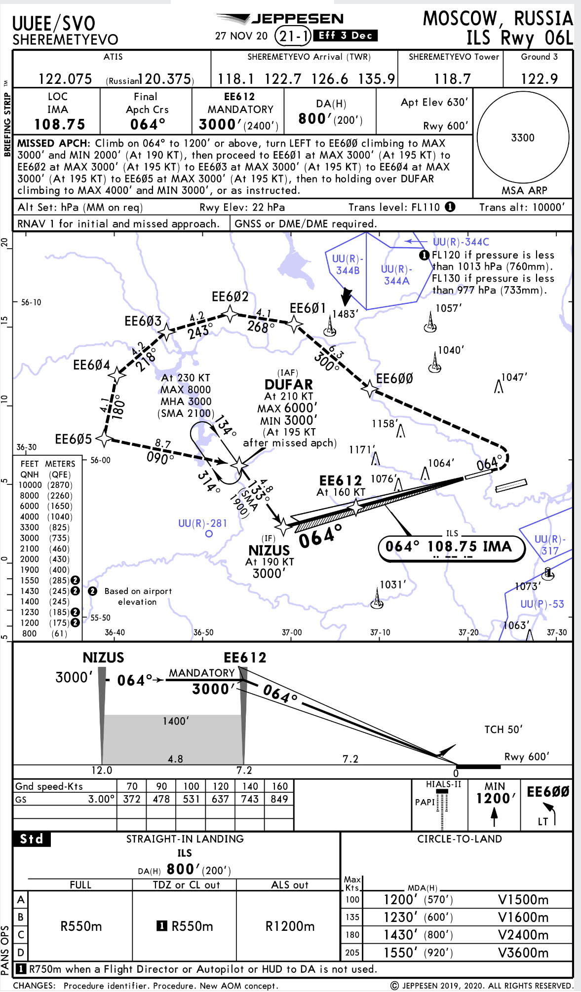
Example "Matryoshka" Approach Chart, from Jeppesen Airway Manual,
Moscow, Russia, ILS Rwy 06L
5
Hybrid procedures
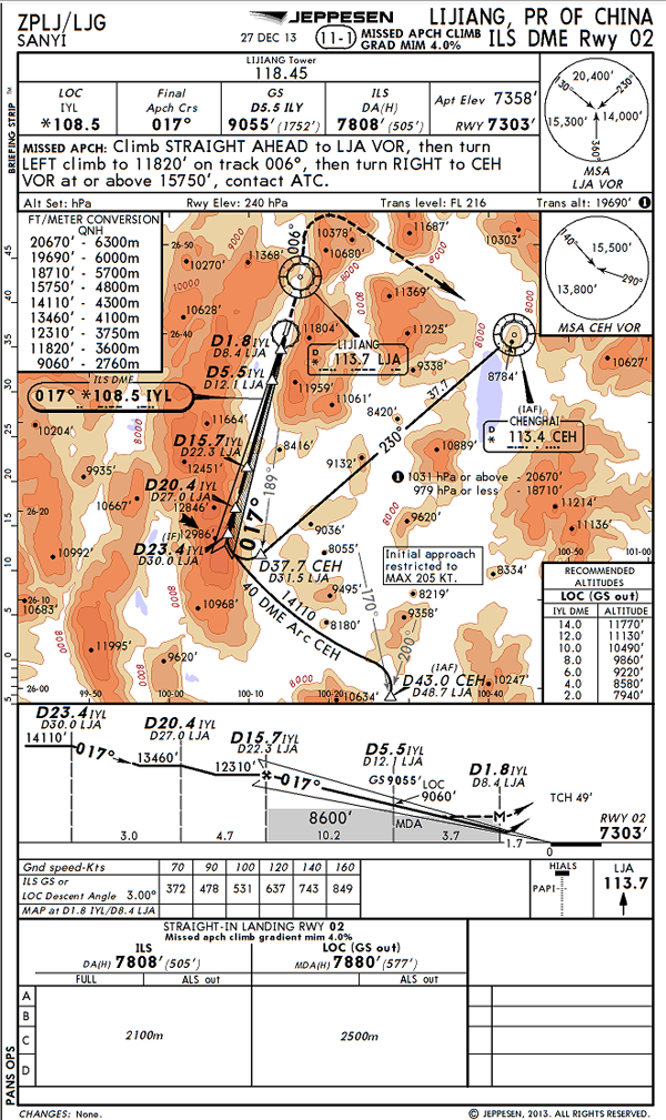
Example Hybrid Approach Chart, from Jeppesen Airway Manual,
Sanyi ILS DME Rwy 02, ZPLJ, page 11-1, 27 Dec 13
Some countries have additional procedures at airports where no transition levels/layers are provided or where the elevation makes setting QFE impossible. Some countries have several procedures within their own borders, China for example:
At aerodromes of high elevation: When the aircraft altimeter subscale cannot be set to the atmospheric pressure at the aerodrome elevation, it will then be set to 1013.2hPa before take-off, with the indicated altitude interpreted as zero altitude. When the aircraft altimeter subscale cannot be set to the atmospheric pressure at the aerodrome elevation, landing is to be made with the assumed zero altitude notified by the air traffic controller before landing.
Source: Jeppesen Airway Manual, Air Traffic Control, State Rules and Procedures, China, Rules and Procedures, 11 Oct 2013
I think this approach used to be QFE and required you to use an altimeter setting with an altitude pad provided by the tower, since you would not be able make your altimeter read zero on the ground at such a high elevation. Tower would give you an altimeter setting and tell you that runway elevation will indicate, for example, 2000 meters on touchdown. It appears most of these high elevation airports, like this one, have converted to QNH. But the high altitude note still appears in the ATC pages.
6
An example from not too long ago
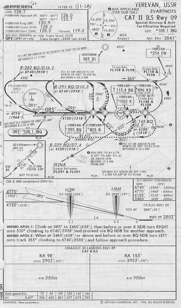
Old USSR Approach, from Jeppesen Airway Manual,
Yerevan Cat II ILS Rwy 09, UBBB, Page 11-1A, 14 Feb 92
My first approach into the old Soviet Union was this one, which looks more complicated than it really is. But back then, with no GPS and FMS to help us, it was a handful. These days as the aircraft get smarter they seem to be cramming more and more stuff on the approach plate which makes it that much more important to study the chart and figure out what you need to know when all the electrons go on strike.
References
(Source material)
ICAO Doc 7030 - Regional Supplementary Procedures, International Civil Aviation Organization, Fifth Edition, 2008
ICAO Doc 7030, Amendment 1, International Civil Aviation Organization, 8 January 2009
Jeppesen Airway Manual